Framed Print > Exploration
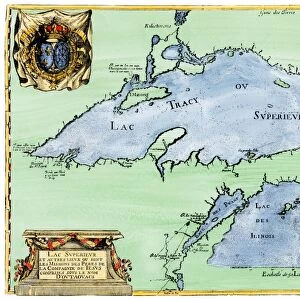
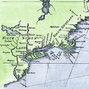
Framed Print : French map of the Great Lakes, 1703


![]()
Framed Photos from North Wind
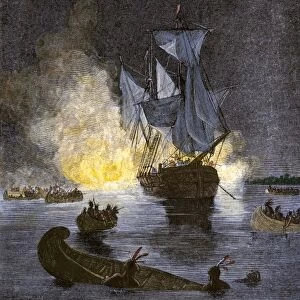
French map of the Great Lakes, 1703
La Hontans map of the Great Lakes and Saint Lawrence valley, 1703.
Hand-colored 19th-century woodcut reproduction of an 18th century illustration
Media ID 5880924
© North Wind Picture Archives
1700s 18th Century Aboriginal America Amerindian Boston Canada Canadian Colonial Colony Discover Document East Eastern English Colony Exploration Explore French French Canada French Colony Great Lakes Indian Iroquois Lake Erie Lake Michigan Lake Ontario Lake Superior Montreal Native Native American New England New France New World New York Quebec Settlement
18"x14" Modern Frame
16x12 Print in an MDF Wooden Frame with 180 gsm Satin Finish Paper. Glazed using shatter proof thin plexiglass. Frame thickness is 1 inch and depth 0.75 inch. Fluted cardboard backing held with clips. Supplied ready to hang with sawtooth hanger and rubber bumpers. Spot clean with a damp cloth. Packaged foam wrapped in a card.
Contemporary Framed and Mounted Prints - Professionally Made and Ready to Hang
Estimated Image Size (if not cropped) is 40.6cm x 35.6cm (16" x 14")
Estimated Product Size is 45.7cm x 35.6cm (18" x 14")
These are individually made so all sizes are approximate
Artwork printed orientated as per the preview above, with landscape (horizontal) orientation to match the source image.
FEATURES IN THESE COLLECTIONS
> Maps
MADE IN THE USA
Safe Shipping with 30 Day Money Back Guarantee
FREE PERSONALISATION*
We are proud to offer a range of customisation features including Personalised Captions, Color Filters and Picture Zoom Tools
SECURE PAYMENTS
We happily accept a wide range of payment options so you can pay for the things you need in the way that is most convenient for you
* Options may vary by product and licensing agreement. Zoomed Pictures can be adjusted in the Cart.