Home > Canadian history
EXPL2A-00184

![]()
Wall Art and Photo Gifts from North Wind
EXPL2A-00184
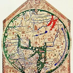
Part of the 1613 Samuel de Champlain map of New France.
Hand-colored woodcut of a 19th-century reproduction of the original ma
Media ID 5879600
© North Wind Picture Archives
1600s 17th Century Atlantic Canada Canadian Cartography Champlain Colonial Colony Discover Exploration Explore French French Canada Gaspee Lake Lake Champlain Maine Massachusetts New England New France New World New York Newfoundland Nova Scotia Ocean Quebec River Samuel De Champlain St Lawrence River Vermont
FEATURES IN THESE COLLECTIONS
> Maps
MADE IN THE UK
Safe Shipping with 30 Day Money Back Guarantee
FREE PERSONALISATION*
We are proud to offer a range of customisation features including Personalised Captions, Color Filters and Picture Zoom Tools
SECURE PAYMENTS
We happily accept a wide range of payment options so you can pay for the things you need in the way that is most convenient for you
* Options may vary by product and licensing agreement. Zoomed Pictures can be adjusted in the Basket.