Home > Maps
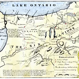
Iroquois Nations map, 1600s

![]()
Wall Art and Photo Gifts from North Wind
Iroquois Nations map, 1600s
French map of the Five Iroquois Nations homeland and Fort Orange (Albany), 1660s.
Hand-colored woodcut of a 17th-century illustration
Media ID 5882657
© North Wind Picture Archives
1600s 17th Century American Indian Amerindian Document East Eastern Indian Iroquois Iroquois Confederacy Lake Ontario Native Native American New York Onandaga Village
FEATURES IN THESE COLLECTIONS
> Maps
MADE IN THE UK
Safe Shipping with 30 Day Money Back Guarantee
FREE PERSONALISATION*
We are proud to offer a range of customisation features including Personalised Captions, Color Filters and Picture Zoom Tools
SECURE PAYMENTS
We happily accept a wide range of payment options so you can pay for the things you need in the way that is most convenient for you
* Options may vary by product and licensing agreement. Zoomed Pictures can be adjusted in the Basket.