mail_outline sales@mediastorehouse.com
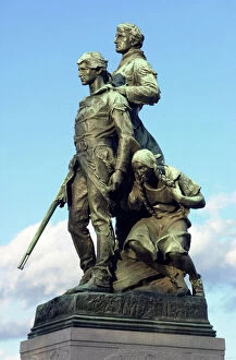
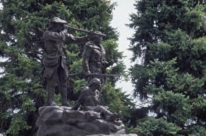
PEXP2D-00013Explorers Meriwether Lewis and William Clark with their Native American guide Sacagawea. Digital photograph of a bronze statue in Charlottesville Virginia
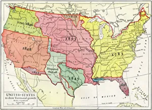
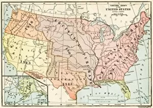
Growth of the United States to 1853U.S. map, showing territorial growth to 1853. Printed color lithograph of a 19th-century illustration
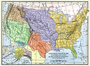
US territorial acquisition during the 1800sMap showiing the territorial growth of the continental US 1776 to 1899. Hand-colored woodcut of a 19th-century illustration
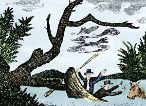
EXPL2A-00269Meriwether Lewis and William Clark expedition losing notes and specimens in a canoe accident on the upper Missouri River. Hand-colored woodcut reproduction of sketch by Patrick Goss
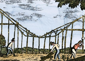
Fort Mandan constructed by Lewis and Clark, 1803Lewis and Clark expedition overwintering along the Missouri River near a Mandan village, 1803-1804. Hand-colored woodcut of a Patrick Goss drawing, a member of the expedition
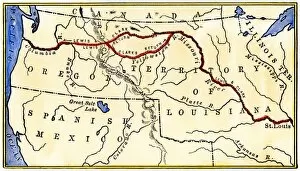
EXPL2A-00035Map of the Lewis and Clark route across Louisiana Territory, 1804-1806. Hand-colored woodcut of a 19th-century illustration
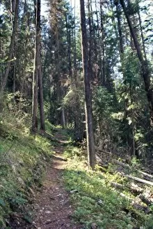
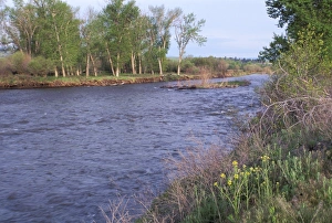
Lolo Creek in the Bitterroot Range, MontanaLolo Creek on Lewis and Clarks trail over the Bitterroot Mountains in Montana. Photograph
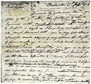
EXPL2A-00339William Clarks letter accepting Lewiss invitation to join the Corps of Discovery expedition, dated Clarksville 1803. Printed halftone reproduction with a watercolor wash
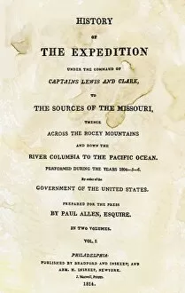
EXPL2A-00351Title page of the first publication of Lewis and Clarks journal and notes, 1814. Woodcut with a watercolor wash
Lewis and Clark monument at Fort Benton, MontanaStatue of Sacagawea guiding Lewis and Clark at Fort Benton, Montana. Photograph
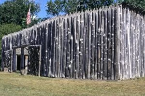
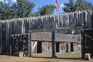
EXPL2P-00031Fort Mandan, a reconstructed Lewis and Clark campsite on the Missouri River, North Dakota. Photograph
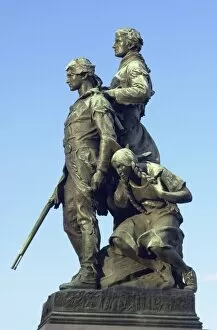
PEXP2D-00014Explorers Meriwether Lewis and William Clark with their Native American guide Sacagawea. Digital photograph of a bronze statue in Charlottesville Virginia
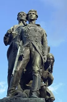
PEXP2D-00011Explorers Meriwether Lewis and William Clark with their Native American guide Sacagawea. Digital photograph of a bronze statue in Charlottesville, Virginia
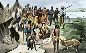
EXPL2A-00133Lewis and Clark expedition trying to make friends with Native Americans during their exploration of Louisiana Territory. Hand-colored halftone of a 19th-century illustration
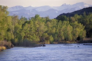
Tobacco Root Mountains and the Jefferson River, MontanaJefferson River, named for Thomas Jefferson by Lewis and Clark. Photograph
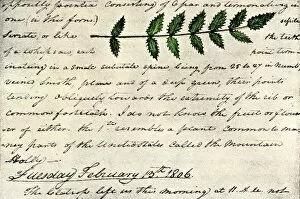
EXPL2A-00168William Clarks sketch of an evergreen shrub leaf in the Lewis and Clark expedition diary, 1806. Hand-colored halftone reproduction of a 19th-century photograph of Clarks handwritten page
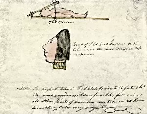
EXPL2A-00167William Clarks sketch of Flathead Indians in his diary of the Lewis and Clark expedition, 1804-1806 Hand-colored halftone reproduction of a 19th-century photograph of Clarks handwritten page
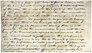
William Clarks invitation from Meriwether Lewis, 1804Meriwether Lewiss letter inviting William Clark to join the expedition to explore the Louisiana Territory. Printed halftone reproduction with a watercolor wash
EXPL2P-00037Fort Mandan, reconstructed Lewis and Clark campsite on Missouri River, North Dakota. Photograph
EXPL2P-00061Lewis and Clark trail over Lolo Pass, Bitterroot Mountains, Montana. Photograph
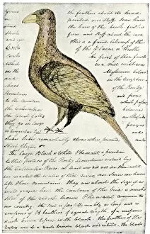
EXPL2A-00117Sketch by William Clark of Cock of the Plains in the Lewis and Clark expedition diary. Hand-colored halftone of a 19th-century reproduction of the diary
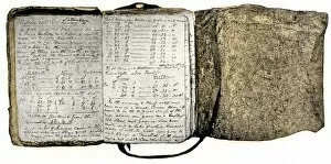
EXPL2A-00116Diary kept by William Clark of the Lewis and Clark expedition 1804 - 1806. Hand-colored halftone of a 19th-century reproduction of the diary
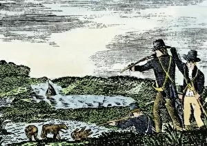
EXPL2A-00092Lewis and Clark shoot a grizzly bear, unknown to whites, during their exploration of Louisiana Territory. Hand-colored woodcut reproduction of sketch by Patrick Goss
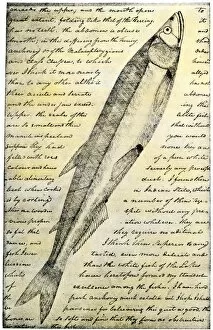
EXPL2A-00166William Clarks sketch of a trout in the Lewis and Clark expedition diary. Hand-colored halftone reproduction of a 19th-century photograph of Clarks handwritten page
Clark Fork, MontanaClark Fork River, named for William Clark, named by Lewis and Clark expedition in Montana. Photograph
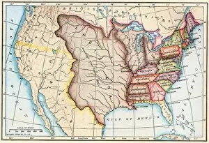
EXPL2A-00041Map of territorial growth of the United States from 1783-1867. Printed color lithograph of a 19th-century illustration
EXPL2A-00062Map of the Louisiana Purchase as understood in 1803, later modified by treaty. Printed color lithograph of a 19th-century illustration