Home > Ancient history
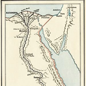
Map of the Mideast in ancient times

![]()
Wall Art and Photo Gifts from North Wind
Map of the Mideast in ancient times
Map of the ancient Near East, birthplace of civilization.
Hand-colored woodcut of a 19th-century illustration
Media ID 5877997
© North Wind Picture Archives
Africa Ancient Ancient Civilization Ancient History Antiquity Arabia Asia Minor Babylon Babylonia Civilization Classical Classical Civilization Egypt Mediterranean Mediterranean Sea Mesopotamia Mid East Middle East North Africa Phoenicia Tyre
FEATURES IN THESE COLLECTIONS
> Maps
MADE IN THE UK
Safe Shipping with 30 Day Money Back Guarantee
FREE PERSONALISATION*
We are proud to offer a range of customisation features including Personalised Captions, Color Filters and Picture Zoom Tools
SECURE PAYMENTS
We happily accept a wide range of payment options so you can pay for the things you need in the way that is most convenient for you
* Options may vary by product and licensing agreement. Zoomed Pictures can be adjusted in the Basket.