
Home > Maps
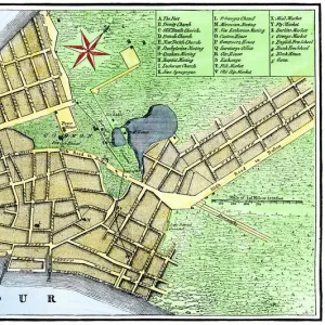
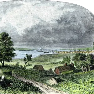
Manhattan map, 1780s

extension
crop_landscape
Cards
Canvas Prints
Fine Art Prints
Mounted Prints
Home Decor
Metal Prints
![]()
Wall Art and Photo Gifts from North Wind
Manhattan map, 1780s
John Hills map of New York City, surveyed in 1782, drawn in 1785.
Hand-colored woodcut reproduction of an 18th-century illustration
Media ID 5882555
© North Wind Picture Archives
1700s 1780s 18th Century Chart Harbor Manhattan New York New York City
FEATURES IN THESE COLLECTIONS
> Maps
MADE IN THE UK
Safe Shipping with 30 Day Money Back Guarantee
FREE PERSONALISATION*
We are proud to offer a range of customisation features including Personalised Captions, Color Filters and Picture Zoom Tools
SECURE PAYMENTS
We happily accept a wide range of payment options so you can pay for the things you need in the way that is most convenient for you
* Options may vary by product and licensing agreement. Zoomed Pictures can be adjusted in the Basket.
Beautiful Photo Prints and Gifts
Professionally Printed
Photo Prints are in stock
Professional quality finish
Made with high-grade materials
Carefully packed to aid safe arrival
Related Images

+
Shipping
+
Choices
+