Home > Maps
EVRV2A-00085

![]()
Wall Art and Photo Gifts from North Wind
EVRV2A-00085
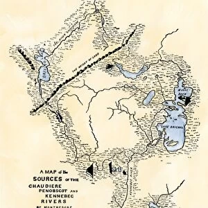
Map of Benedict Arnolds route to invade Quebec during the American Revolution, 1775.
Hand-colored woodcut of a 19th-century illustration
Media ID 5881895
© North Wind Picture Archives
1700s 1770s 1775 18th Century American Revolution Army Arnold Attack Benedict Arnold Canada Continental Army Invade Invasion Maine Military New England Quebec Revolutionary War Route Wilderness
MADE IN THE UK
Safe Shipping with 30 Day Money Back Guarantee
FREE PERSONALISATION*
We are proud to offer a range of customisation features including Personalised Captions, Color Filters and Picture Zoom Tools
SECURE PAYMENTS
We happily accept a wide range of payment options so you can pay for the things you need in the way that is most convenient for you
* Options may vary by product and licensing agreement. Zoomed Pictures can be adjusted in the Basket.