mail_outline sales@mediastorehouse.com
216 items
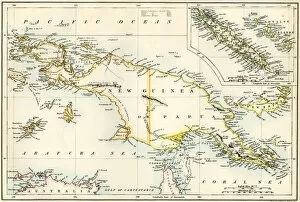
GPAC2A-00023Map of New Guinea and New Caledonia, 1870s. Printed color lithograph of a 19th-century illustration
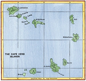
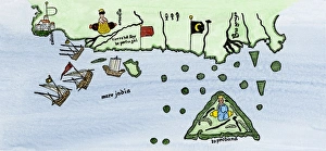
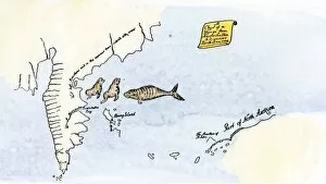
Cape Verde Islands mapMap of the Cape Verde Islands in the Atlantic. Hand-colored woodcut of a 19th-century illustration
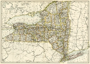
New York map, 1870sMap of New York State, 1870s. Printed color lithograph of a 19th-century illustration
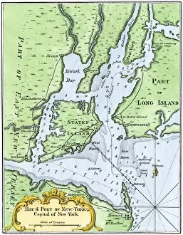
USNY2A-00037Bellins map of the New York Bay, 1764. Hand-colored woodcut reproduction of an 18th-century illustration
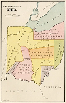
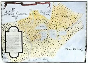
Ohios early land divisionsLand division and early settlements in Ohio Territory. Printed color lithograph of a 19th-century illustration
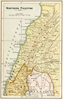
GMDE2A-00055Map of northern Palestine in ancient times. Printed color lithograph of a 19th-century illustration
GMDE2A-00054Map of Arabia, 1870s. Printed color lithograph, 19th century
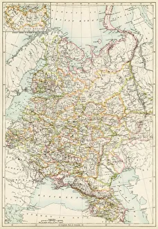
Russia under the tsarsMap of Russia, 1870s. Color lithograph reproduction of a 19th-century illustration
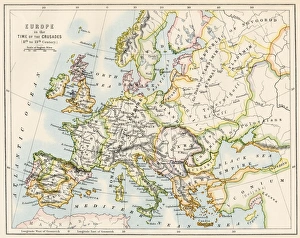
Europe at the time of the CrusadesMap of Europe during the Crusades, 1000 to 1200 AD. Printed color lithograph reproduction of a 19th-century illustration
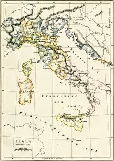
GEUR2A-00122Map of Italy showing political divisions before 1797. Color lithograph, 19th century
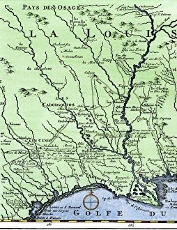
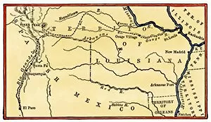
DeSotos route in LouisianaWestern part of De Sotos route, from Desisles map published in 1707. Hand-colored woodcut reproduction of an 18th-century illustration
EXPL2A-00354Dauphin Map by Pierre Desceliers made for Prince Henry (who became Henri II) by order of the French King Francis I, 1546. Printed color halftone reproduction 19th century
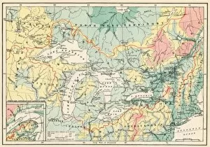
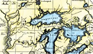
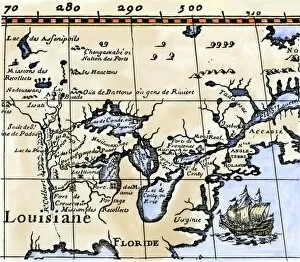
EXPL2A-00357Map of the Great Lakes and the St. Lawrence watershed. Printed color lithograph, 19th century
EXPL2A-00149Route of Zebulon Pike across western territory to explore Colorado region 1805 - 1806. Hand-colored woodcut of a 19th-century illustration
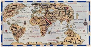
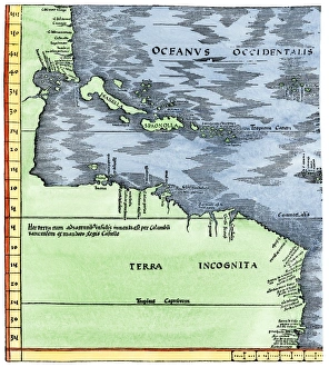
EXPL2A-00065World map of the flat earth printed by Beatus Rhenanus Bildaus Rheinau early 1500s - North is left, Mediterranean Sea middle Printed color lithograph reproduction 19th century
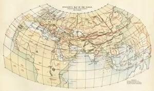
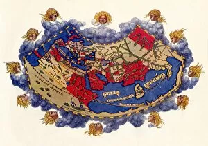
EXPL2A-00353Ptolemys map of the world shown in red, true locations in black. Printed color lithograph 19th century
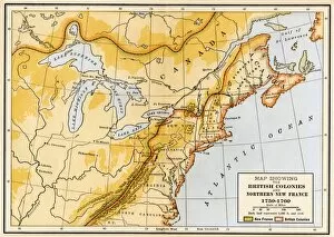
EVNT2A-00019Map showing British colonies and northern New France during the French and Indian War, 1750s. Printed color lithograph of a 19th century illustration
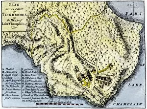
EVNT2A-00209Map of Fort Ticonderoga in 1759, during the French and Indian War. Hand-colored printed halftone reproduced in the 19th century
Spanish Armadas route in 1588Chart of the Spanish Armadas course, 1588. Hand-colored engraving
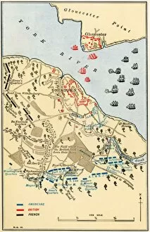
EVRV2A-00106Map of the Battle of Yorktown where the British Army was defeated by the American and French alliance in the Revolutionary War, 1781. Printed color lithograph
EVRV2A-00174Map showing the thirteen colonies which joined together as the original thirteen states in 1776. Hand-colored woodcut of a 19th-century illustration
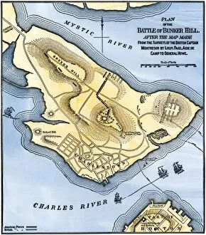
EVRV2A-00184Map of the Battle of Bunker Hill, drawn from a British map. Hand-colored woodcut reproduction
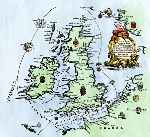
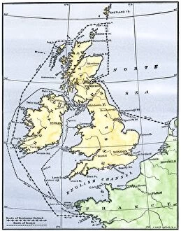
EVRV2A-00215Routes of the American ships Ranger and Bonhomme Richard raiding the British Isles during the American Revolution. Hand-colored woodcut of a 19th-century illustration
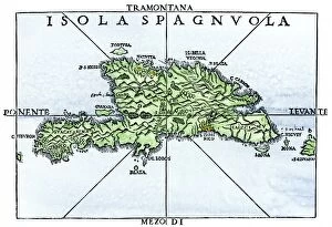
EXPL2A-00227Map of Hispaniola in 1534, from cartography of Peter Martyr and Oviedo. Hand-colored 19th-century woodcut reproduction of a 16th-century map
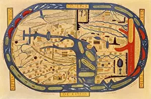
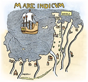
India coast, 1459The Malabar coast of India, from Fra Mauros map, 1459 (south is at the top). Digitally colored woodcut reproduction
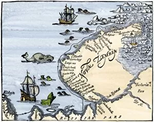
EXPL2A-00346Early map showing Nova Zembla off the Arctic coast of Russia, probably 1600s. Hand-colored 19th-century woodcut reproduction
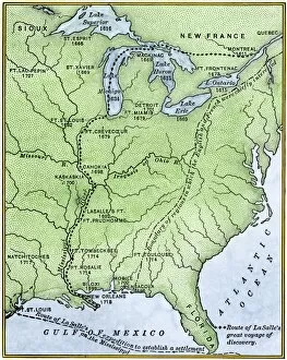
EXPL2A-00171Map showing the route of La Salles explorations in North America, late 1600s. Hand-colored woodcut of a 19th-century illustration
EXPL2A-00197Hudsons map of his voyages in the Arctic, published in 1612. Hand-colored 19th-century reproduction of a woodcut from Hudsons " Voyages" published in 1612
EXPL2A-00218French missionary Louis Hennepins map of the Mississippi River valley, Gulf Coast, and Great Lakes after LaSalle expeditions 1697
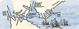
EXPL2A-00220John Whites map of the Virginia and Carolina coast where Roanoke Colony was located, 1500s. Hand-colored 19th-century reproduction engraving
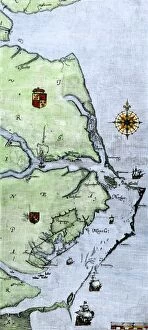
Virginia and North Carolina coast, 1500sJohn Whites map of the Atlantic coast of North Carolina and Virginia, 1500s. Hand-colored 19th-century woodcut reproduction
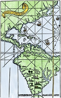
South America mapped after Magellans voyage, 1519New World map after Magellans passage around Cape Horn in 1519. Hand-colored woodcut of a 19th century illustration
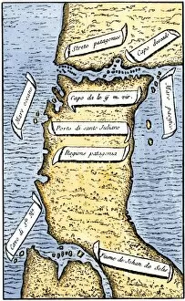
EXPL2A-00239First map of the Strait of Magellan from Magellans circumnavigation of the earth in 1519 showing north at the bottom. Hand-colored 19th-century woodcut reproduction of Pigafettas 16th century map
Portuguese traders in India and Ceylon, 1500Calcutta and the southern coast of India, from Juan de la Cosas map, 1500. Hand-colored woodcut reproduction of a 16th-century illustration
EXPL2A-00329Louis Joliets map of New France, 1673-1674, including the upper Mississippi River he and Jacques Marquette discovered. Hand-colored halftone reproduction
EXPL2A-00330North American colonies at the close of the French and Indian War, 1760s. Printed color lithograph 19th century
EXPL2A-00350French map of the Great Lakes and upper Mississippi River region, circa 1700. Hand-colored 19th-century woodcut reproduction
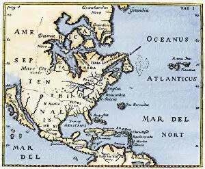
EXPL2A-00375Map of North America as known in the mid-1600s. Hand-colored woodcut reproduction of an illustration in Campanius, 1702
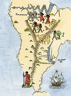
EXPL2A-00026Map of South America, from Sebastian Cabots map of the world, 1544. Hand colored 19th-century woodcut reproduction of the original map
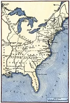
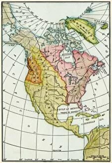
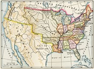
EXPL2A-00022Map of the United States in 1819, showing territory under Spanish and British control. Printed color halftone of a 19th-century illustration
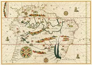
EXPL2A-00021Map of South America from the Spanish atlas executed at Messina in 1582 by Joan Martines. Printed color lithograph reproduction 19th century
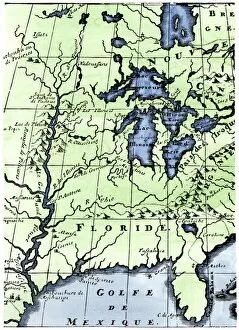
EXPL2A-00016Hennepins map of New France and Louisiana - La Carte de la Nouvelle France, 1683. Hand-colored 19th-century woodcut reproduction of the original map
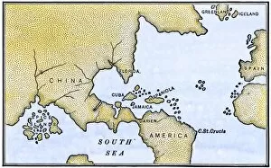
Early map of the New World, 1513Tabula Terre Nove 1513: the Admirals Map of the Caribbean and Terra Incognita (unknown lands). Hand-colored woodcut reproduction
EXPL2A-00061Ptolemys world map, circa 150 AD, from the edition of 1472. Color halftone reproduction of the first printed edition of 1472
Isthmus of Panama, 1744Map from Oexmelins Histoire of the Isthmus of Panama, 1744. Hand-colored woodcut
EXPL2A-00150Chart of Vitus Berings voyage from Kamchatka, Russia, to North America, 1700s. Hand-colored 19th-century woodcut reproduction
EXPL2A-00147World map after the disoveries of Columbus and Balboa, showing the prevalent idea that South America was attached to Asia. Hand-colored woodcut of a 19th-century illustration
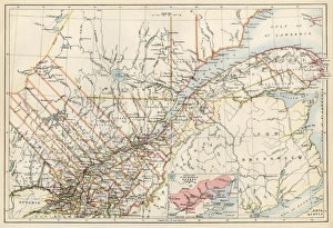
Quebec, 1870sMap of Quebec province, Canada, 1870s. Printed color lithograph