Home > Latin America:Caribbean
EXPL2A-00227

![]()
Wall Art and Photo Gifts from North Wind
EXPL2A-00227
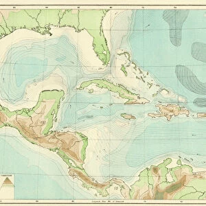
Map of Hispaniola in 1534, from cartography of Peter Martyr and Oviedo.
Hand-colored 19th-century woodcut reproduction of a 16th-century map
Media ID 5881793
© North Wind Picture Archives
1500s 16th Century Caribbean Cartography Colonial Colony Discover Dominican Republic Expedition Exploration Explore Haiti Hispaniola Island Navigation New Spain New World Santo Domingo Settlement Spanish West Indies
FEATURES IN THESE COLLECTIONS
> Maps
MADE IN THE UK
Safe Shipping with 30 Day Money Back Guarantee
FREE PERSONALISATION*
We are proud to offer a range of customisation features including Personalised Captions, Color Filters and Picture Zoom Tools
SECURE PAYMENTS
We happily accept a wide range of payment options so you can pay for the things you need in the way that is most convenient for you
* Options may vary by product and licensing agreement. Zoomed Pictures can be adjusted in the Basket.