mail_outline sales@mediastorehouse.com
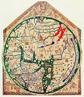
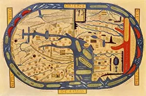
EXPL2A-00352The Hereford Mappa Mundi of 1280 - Jerusalem is at the center, Europe lower left, Africa lower right. Printed color halftone reproduction 19th century
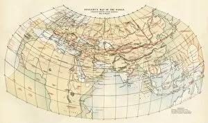
EXPL2A-00014Ptolemys map of the world, illustrating a concept of the flat earth. Hand-colored 19th-century woodcut reproduction
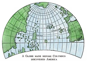
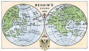
Globe of 1492, lacking the New WorldDiagram of Martin Behaims globe, made just before Columbus discovered America. Hand-colored woodcut of a 19th-century illustration
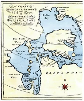
EXPL2A-00284Early map of Hudsons Strait and Hudsons Bay, 1662, in Arctic Canada. Hand-colored 19th-century woodcut reproduction
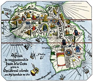
Vasco da Gamas route around Africa, 1400sAfrica as known after Vasco da Gamas discoveries, from map of Juan de la Cosa, 1500. Hand-colored woodcut reproduction
Behaims 1492 globe showing a round Earth but no New WorldDiagram of globe by Martin Behaim, without the New World, created in 1492. Hand-colored woodcut of a 19th-century illustration
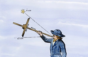
Use of a quadrant for navigationSailor sighting on a star with a quadrant for navigation. Hand-colored woodcut of a 19th-century illustration
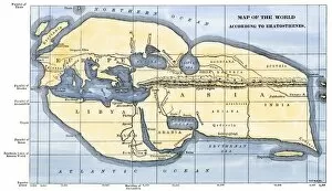
EXPL2A-00317Map of the world according to ancient Greek geographer Eratosthenes. Hand-colored 19th-century woodcut reproduction
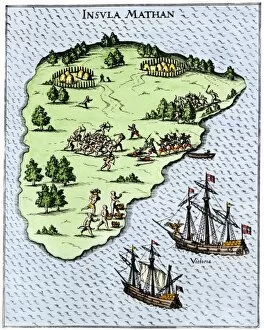
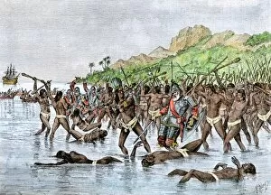
EXPL2A-00268Magellans ships at Mactan, an island in the Philippines, where Magellan was killed in a battle with natives, 1521. Hand-colored 19th-century halftone reproduction of a 16th-century engraving
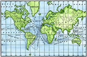
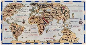
Great voyages of the age of explorationMap of great voyages from 1492 to 1580. Hand-colored woodcut of a 19th-century illustration
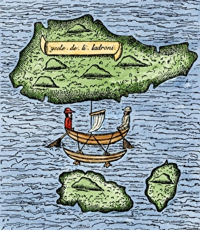
Mariana Islands in the Pacific discovered by Magellan, 1521The Ladrones, later called the Marianas, and a native outrigger drawn by Pigafetta on the Magellan expedition, 1521. Hand-colored woodcut reproduction of a 16th-century illustration
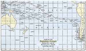
Magellans route across the PacificRoute of Magellans ships across the Pacific while circumnavigating the earth, 1519-1522. Hand-colored woodcut of a 19th-century illustration
EXPL2A-00065World map of the flat earth printed by Beatus Rhenanus Bildaus Rheinau early 1500s - North is left, Mediterranean Sea middle Printed color lithograph reproduction 19th century
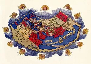
EXPL2A-00353Ptolemys map of the world shown in red, true locations in black. Printed color lithograph 19th century
Magellan sails around South America to circumnavigate the earthMagellan passing through his Strait to sail around South America on his circumnavigation of the earth, 1519-1522. Hand-colored woodcut reproduction
EXPL2A-00233Cartiers ships leaving St. Malo, France, to sail for North America, 1530s. Hand-colored woodcut of a 19th-century illustration
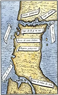
EXPL2A-00239First map of the Strait of Magellan from Magellans circumnavigation of the earth in 1519 showing north at the bottom. Hand-colored 19th-century woodcut reproduction of Pigafettas 16th century map
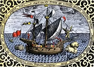
EXPL2A-00240Ship " Victoria, " one of Magellans fleet which circumnavigated the earth, 1519-1520. Hand-colored 19th-century woodcut reproduction of an earlier illustration
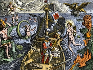
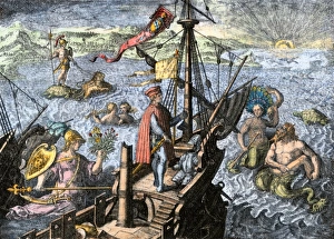
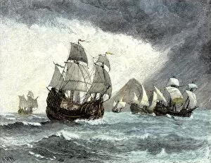
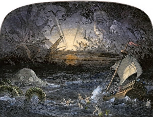
Sailing unknown seas in the Age of DiscoveryNavigating the Sea of Darkness. Hand-colored woodcut reproduction
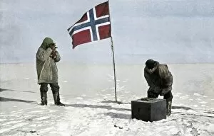
PEXP2A-00120Roald Amundsen, first to reach the South Pole, fixing position at the pole, 1911. Hand-colored halftone reproduction of a photograph
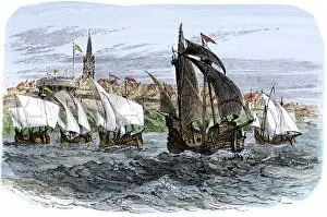
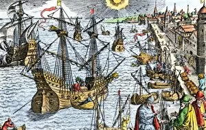
EXPL2A-00107Ships in busy Lisbon harbor, circa 1600. Hand-colored woodcut of a 19th-century reproduction of the original illustration from DeBry
EXPL2A-00024Map of the Atlantic with the New World coast, drawn in 1500 by Juan de la Cosa, Columbus pilot. Hand colored 19th-century woodcut reproduction of the original chart
EXPL2A-00020Ships of Ferdinand Magellan rounding Tierra del Fuego to circumnavigate the earth 1519 to 1521. Hand-colored woodcut of a 19th-century illustration
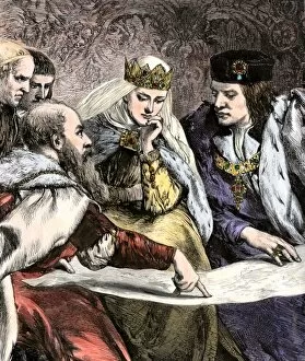
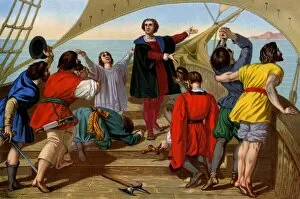
EXPL2A-00018Columbus showing a map to Ferdinand and Isabella of Spain. Hand-colored woodcut of a 19th-century illustration
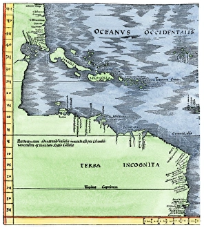
Early map of the New World, 1513Tabula Terre Nove 1513: the Admirals Map of the Caribbean and Terra Incognita (unknown lands). Hand-colored woodcut reproduction
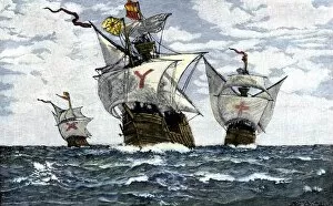
EXPL2A-00009Three ships of Columbus approaching the New World, 1492. Hand-colored woodcut of a 19th-century illustration
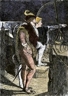
Columbus first sighting the New WorldColumbus getting his first sight of the New World from the deck of the Santa Maria, 1492. Hand-colored woodcut of a 19th-century illustration
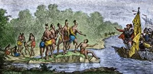
EXPL2A-00006Columbuss hospitable reception by Guacanagari, Caribbean chief, after shipwreck of Santa Maria, 1492. Hand-colored woodcut of a 19th-century illustration
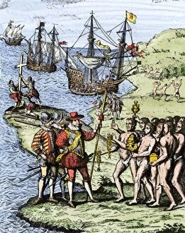
EXPL2A-00004Expedition of Christopher Columbus landing at Hispaniola, 1492. Hand-colored woodcut of a 19th-century illustration
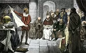
EXPL2A-00001Christopher Columbus promoting his ideas before the Council at Salamanca. Hand-colored woodcut of a 19th-century illustration
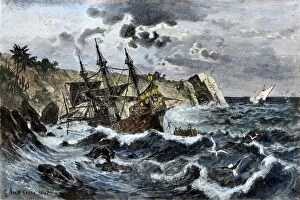
EXPL2A-00036Wreck of Columbuss flagship Santa Maria on the coast of Hispaniola, 1492. Hand-colored woodcut of a 19th-century illustration
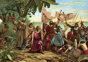
EXPL2A-00066Landing of Columbus expedition on the island of Guanahane in 1492. Printed color lithograph of a 19th-century painting by Dioscoro Puebla
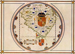
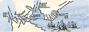
Portuguese map of the tip of South America, 1571Map of South America printed in Lisbon, 1571. Printed color halftone reproduction
EXPL2A-00088Death of Magellan on the island of Mactan, Philippines, in 1521, before completing his circumnavigation of the earth. Hand-colored woodcut of a 19th-century illustration
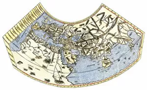
EXPL2A-00061Ptolemys world map, circa 150 AD, from the edition of 1472. Color halftone reproduction of the first printed edition of 1472
EXPL2A-00055First view of the New World by Columbus and his crew aboard the " Santa Maria, " 1492. Printed color lithograph of a 19th-century illustration
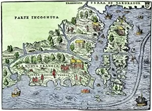
EXPL2A-00126Map of New France, 1550, showing the coast of Canada and the Gulf of Saint Lawrence Hand-colored woodcut
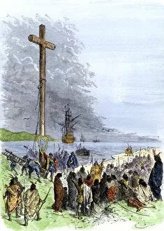
EXPL2A-00230Jacques Cartier erects a cross along the Saint Lawrence River, claiming Quebec for France, 1534. Hand-colored woodcut of a 19th-century illustration
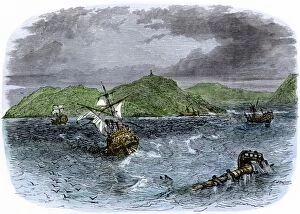
EXPL2A-00231Shipwrecks in the Strait of Belle Isle, Gulf of St Lawrence, Canada. Hand-colored woodcut of a 19th-century illustration
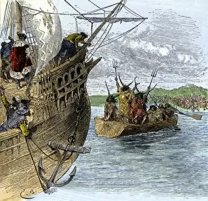
EXPL2A-00234Huron chief Donnacona warns Cartiers expedition not to sail up the St Lawrence River, 1535. Hand-colored woodcut of a 19th-century illustration
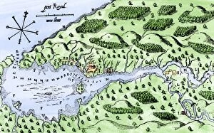
EXPL2A-00297Champlains 1613 map of his settlement at Port Royal, now Annapolis Royal, Nova Scotia, Canada. Hand-colored 19th-century woodcut reproduction of Champlains drawing
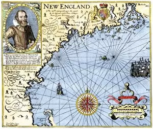
EXPL2A-00291John Smiths map of New England, with inset portrait, circa 1620. Hand-colored 19th-century woodcut reproduction of the original
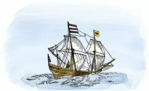
EXPL2A-00188One of Henry Hudsons ships, early 1600s. Hand-colored 19th-century reproduction of a woodcut from Hudsons " Voyages" published in 1612
Sea of DarknessTerrors in the Sea of Darkness. Hand-colored woodcut of a 19th-century illustration
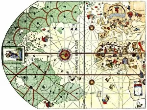
EXPL2A-00354Dauphin Map by Pierre Desceliers made for Prince Henry (who became Henri II) by order of the French King Francis I, 1546. Printed color halftone reproduction 19th century
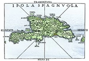
EXPL2A-00227Map of Hispaniola in 1534, from cartography of Peter Martyr and Oviedo. Hand-colored 19th-century woodcut reproduction of a 16th-century map
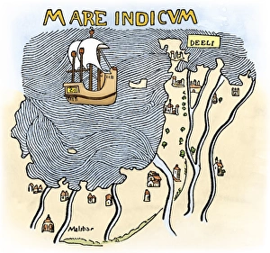
India coast, 1459The Malabar coast of India, from Fra Mauros map, 1459 (south is at the top). Digitally colored woodcut reproduction
EXPL2A-00197Hudsons map of his voyages in the Arctic, published in 1612. Hand-colored 19th-century reproduction of a woodcut from Hudsons " Voyages" published in 1612