mail_outline sales@mediastorehouse.com
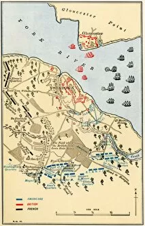
EVRV2A-00106Map of the Battle of Yorktown where the British Army was defeated by the American and French alliance in the Revolutionary War, 1781. Printed color lithograph
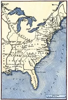
EVRV2A-00174Map showing the thirteen colonies which joined together as the original thirteen states in 1776. Hand-colored woodcut of a 19th-century illustration
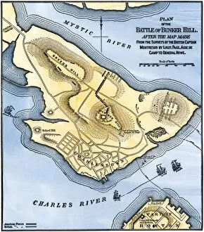
EVRV2A-00184Map of the Battle of Bunker Hill, drawn from a British map. Hand-colored woodcut reproduction
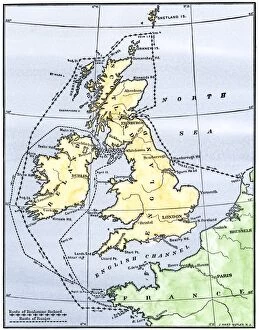
EVRV2A-00215Routes of the American ships Ranger and Bonhomme Richard raiding the British Isles during the American Revolution. Hand-colored woodcut of a 19th-century illustration
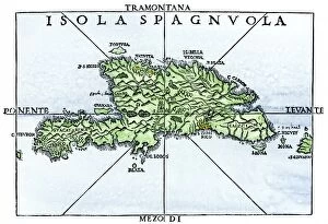
EXPL2A-00227Map of Hispaniola in 1534, from cartography of Peter Martyr and Oviedo. Hand-colored 19th-century woodcut reproduction of a 16th-century map
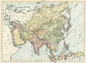
GASI2A-00005Map of Asia, circa 1870. Printed color lithograph, 19th century
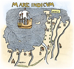
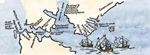
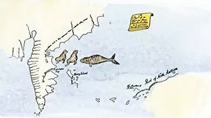
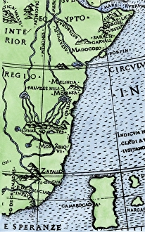
India coast, 1459The Malabar coast of India, from Fra Mauros map, 1459 (south is at the top). Digitally colored woodcut reproduction
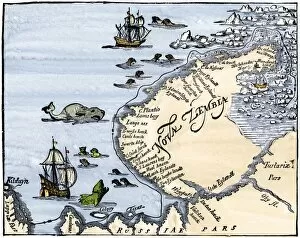
EXPL2A-00346Early map showing Nova Zembla off the Arctic coast of Russia, probably 1600s. Hand-colored 19th-century woodcut reproduction
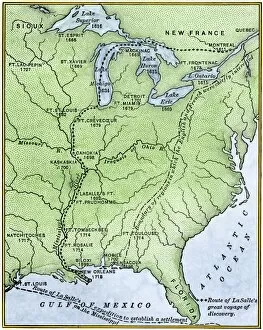
EXPL2A-00171Map showing the route of La Salles explorations in North America, late 1600s. Hand-colored woodcut of a 19th-century illustration
EXPL2A-00197Hudsons map of his voyages in the Arctic, published in 1612. Hand-colored 19th-century reproduction of a woodcut from Hudsons " Voyages" published in 1612
EXPL2A-00218French missionary Louis Hennepins map of the Mississippi River valley, Gulf Coast, and Great Lakes after LaSalle expeditions 1697
Virginia and North Carolina coast, 1500sJohn Whites map of the Atlantic coast of North Carolina and Virginia, 1500s. Hand-colored 19th-century woodcut reproduction
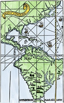
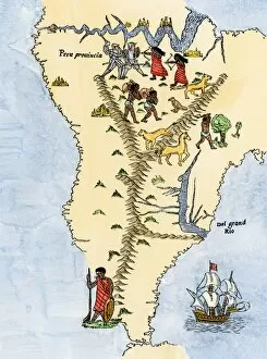
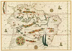
South America mapped after Magellans voyage, 1519New World map after Magellans passage around Cape Horn in 1519. Hand-colored woodcut of a 19th century illustration
EXPL2A-00329Louis Joliets map of New France, 1673-1674, including the upper Mississippi River he and Jacques Marquette discovered. Hand-colored halftone reproduction
EXPL2A-00330North American colonies at the close of the French and Indian War, 1760s. Printed color lithograph 19th century
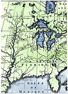
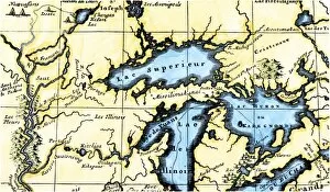
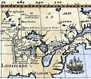
EXPL2A-00350French map of the Great Lakes and upper Mississippi River region, circa 1700. Hand-colored 19th-century woodcut reproduction
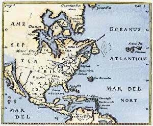
EXPL2A-00375Map of North America as known in the mid-1600s. Hand-colored woodcut reproduction of an illustration in Campanius, 1702
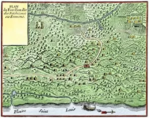
EXPL2A-00124Fort Rozalie des Natchez on the Mississippi River 1700s - North is to the right. Hand-colored woodcut of a map published in 1770. Fleuve Saint Louis was the French name for the Mississippi River
EXPL2A-00026Map of South America, from Sebastian Cabots map of the world, 1544. Hand colored 19th-century woodcut reproduction of the original map
EXPL2A-00022Map of the United States in 1819, showing territory under Spanish and British control. Printed color halftone of a 19th-century illustration
EXPL2A-00021Map of South America from the Spanish atlas executed at Messina in 1582 by Joan Martines. Printed color lithograph reproduction 19th century
EXPL2A-00016Hennepins map of New France and Louisiana - La Carte de la Nouvelle France, 1683. Hand-colored 19th-century woodcut reproduction of the original map
EXPL2A-00032Christopher Columbus studying a map in his studio in Spain 1400s. Hand-colored woodcut of a 19th-century illustration
Isthmus of Panama, 1744Map from Oexmelins Histoire of the Isthmus of Panama, 1744. Hand-colored woodcut
EXPL2A-00148New World geography according to a mapmaker of 1540. Hand-colored woodcut of a 19th-century illustration
EXPL2A-00150Chart of Vitus Berings voyage from Kamchatka, Russia, to North America, 1700s. Hand-colored 19th-century woodcut reproduction
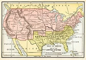
EVCW2A-00009Map of the United States in 1861, at the start of the Civil War. Printed color lithograph 19th century
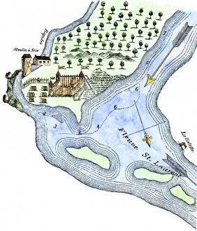
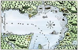
EXPL2A-00183Samuel de Champlains fortified camp at Quebec on the St Lawrence River, 1600s Hand-colored 19th-century woodcut of a 17th-century map
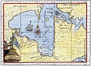
EXPL2A-00190Map of Hudsons Bay, Canada, showing Hudsons Strait, 1722. Hand-colored 19th-century woodcut reproduction of an 18th-century map
Champlains Quebec settlement, 1613Champlains settlement at Quebec in New France, 1613. Hand-colored woodcut of a 17th-century illustration
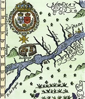
EXPL2A-00246Hochelaga, site of Montreal, shown as a Native American village in Lescarbots map, 1609. Hand-colored 19th-century woodcut reproduction of a 17th-century document
EXPL2A-00058Samuel de Champlains map of the Gaspee and Gulf of the Saint Lawrence River, 1632. Hand-colored woodcut reproduction of the original map
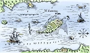
EXPL2A-00296Map of Champlains settlement on the Isle de Sainte Croix, Canada, 1613. Hand-colored 19th-century woodcut reproduction of the original map
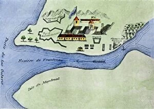
EXPL2A-00267Fort Frontenac on Lake Ontario, 1600s, at the head of the St Lawrence River, now Kingston, Ontario. Hand-colored 19th century halftone reproduction of the original map
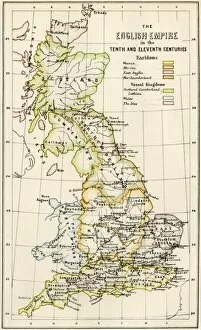
GGBR2A-00069Map of English holdings in the 10th and 11th centuries, showing earldomes and vassal kingdoms. Printed color lithograph, 19th-century
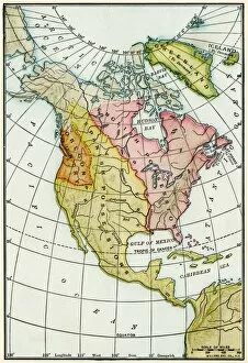
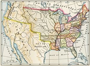
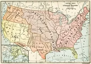
EXPL2A-00041Map of territorial growth of the United States from 1783-1867. Printed color lithograph of a 19th-century illustration
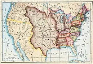
EXPL2A-00062Map of the Louisiana Purchase as understood in 1803, later modified by treaty. Printed color lithograph of a 19th-century illustration
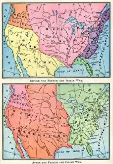
EXPL2A-00151Maps of North American colonies before and after the French and Indian War, 1700s. Printed color lithograph of a 19th century illustration
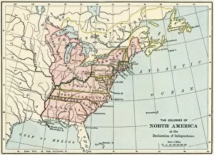
EVRV2A-00230British North American colonies in 1776. Printed color lithograph of a 19th-century illustration
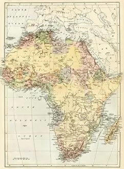
GAFR2A-00046Map of Africa in the 1870s. Printed color lithograph, 19th century
Cape of Good Hope mapped at its correct latitude, 1508First map showing Africas southern point at the correct latitude, from Ruysch 1508. Hand-colored woodcut reproduction of a 16th-century illustration