mail_outline sales@mediastorehouse.com
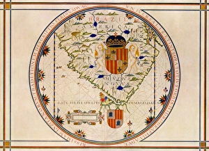
EXPL2A-00353Ptolemys map of the world shown in red, true locations in black. Printed color lithograph 19th century
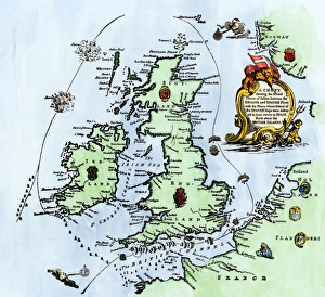
Spanish Armadas route in 1588Chart of the Spanish Armadas course, 1588. Hand-colored engraving
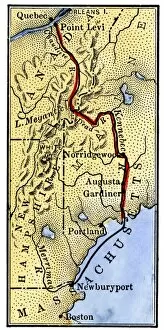
EVRV2A-00085Map of Benedict Arnolds route to invade Quebec during the American Revolution, 1775. Hand-colored woodcut of a 19th-century illustration
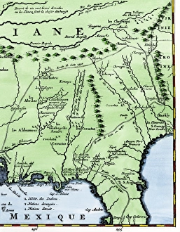
Map of part of DeSotos route, 1500sEastern portion of De Sotos route across southeastern North America, 1500s. Hand-colored woodcut reproduction of a 1593 illustration
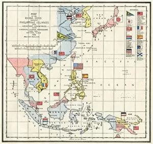
EVNT2A-00313Map of the China Seas, Philippines, and European colonies in the region, 1898. Printed color lithograph 19th century
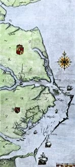
EXPL2A-00220John Whites map of the Virginia and Carolina coast where Roanoke Colony was located, 1500s. Hand-colored 19th-century reproduction engraving
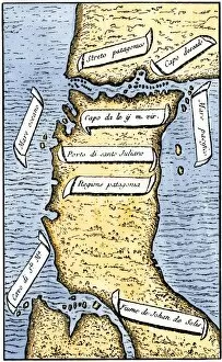
EXPL2A-00239First map of the Strait of Magellan from Magellans circumnavigation of the earth in 1519 showing north at the bottom. Hand-colored 19th-century woodcut reproduction of Pigafettas 16th century map
Portuguese traders in India and Ceylon, 1500Calcutta and the southern coast of India, from Juan de la Cosas map, 1500. Hand-colored woodcut reproduction of a 16th-century illustration
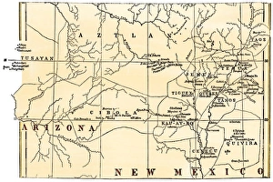
Pueblo Indian villages of the 1800sMap of the Pueblo region, showing inhabited pueblos and ruins, 1800s. Hand-colored woodcut of a 19th-century illustration
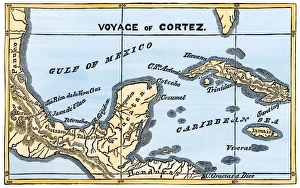
Mexico at the time of Cortes, 1500sMap of Cortes landing area in Mexico, 1519. Hand-colored woodcut of a 19th-century illustration
North American territories in 1783North America at the close of the Revolution - Treaty of Paris, 1783. Printed color lithograph
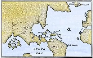
EXPL2A-00024Map of the Atlantic with the New World coast, drawn in 1500 by Juan de la Cosa, Columbus pilot. Hand colored 19th-century woodcut reproduction of the original chart
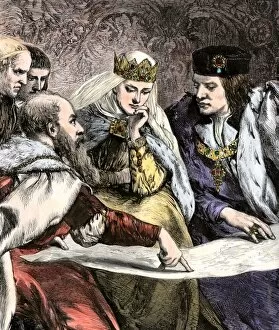
EXPL2A-00018Columbus showing a map to Ferdinand and Isabella of Spain. Hand-colored woodcut of a 19th-century illustration
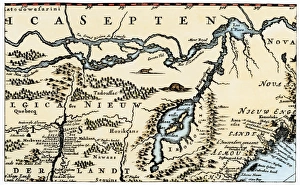
Dutch map of eastern North America, 1670Nova Belgh Tabula, map of New Netherland and New England, 1670. Hand-colored woodcut reproduction
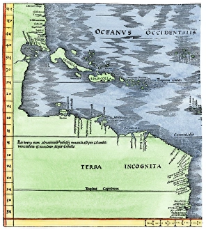
Early map of the New World, 1513Tabula Terre Nove 1513: the Admirals Map of the Caribbean and Terra Incognita (unknown lands). Hand-colored woodcut reproduction
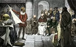
EXPL2A-00001Christopher Columbus promoting his ideas before the Council at Salamanca. Hand-colored woodcut of a 19th-century illustration
Portuguese map of the tip of South America, 1571Map of South America printed in Lisbon, 1571. Printed color halftone reproduction
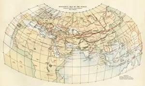
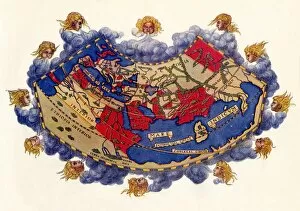
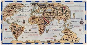
EXPL2A-00061Ptolemys world map, circa 150 AD, from the edition of 1472. Color halftone reproduction of the first printed edition of 1472
EXPL2A-00147World map after the disoveries of Columbus and Balboa, showing the prevalent idea that South America was attached to Asia. Hand-colored woodcut of a 19th-century illustration
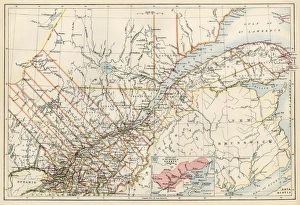
Quebec, 1870sMap of Quebec province, Canada, 1870s. Printed color lithograph
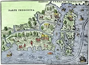
EXPL2A-00126Map of New France, 1550, showing the coast of Canada and the Gulf of Saint Lawrence Hand-colored woodcut
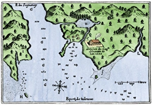
Champlains Tadoussac settlement, 1613Champlains map of Tadoussac settlement in New France, 1613. Hand-colored woodcut of a 17th-century illustration
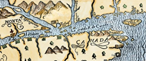
Quebec and Tadoussac, 1609Lescarbots map of the St. Lawrence and the Saguenay showing Quebec (Kebec) in Canada, 1609. Hand-colored woodcut of a 19th-century illustration
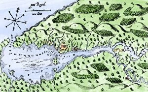
EXPL2A-00297Champlains 1613 map of his settlement at Port Royal, now Annapolis Royal, Nova Scotia, Canada. Hand-colored 19th-century woodcut reproduction of Champlains drawing
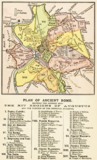
Ancient Romes 14 regionsMap of ancient Rome showing the fourteen regions under Caesar Augustus, circa 1 AD. Printed color lithograph reproduction of a 19th-century illustration
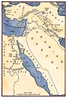
Map of the Mideast in ancient timesMap of the ancient Near East, birthplace of civilization. Hand-colored woodcut of a 19th-century illustration
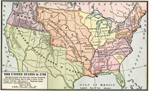
EXPL2A-00039Map of the US in 1792, showing colonial claims on Oregon Territory. Printed color halftone of a 19th century illustration
EXPL2A-00038Map of the U.S. boundary disputes with Spain and Great Britain, 1810-1812. Printed color lithograph of a 19th-century illustration
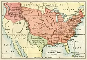
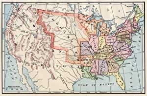
United States territory in 1830Map of the United States in 1830. Printed color lithograph
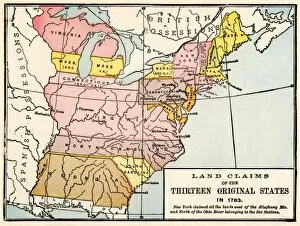
EXPL2A-00191Map showing land claims of the 13 original states in 1783. Printed color lithograph of a 19th-century illustration
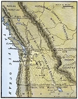
EXPL2A-00210Map of Oregon Territory showing boundary of US with English Canada under dispute until 1846. Hand-colored woodcut of a 19th-century illustration
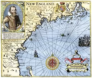
EXPL2A-00291John Smiths map of New England, with inset portrait, circa 1620. Hand-colored 19th-century woodcut reproduction of the original
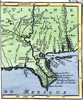
EXPL2A-00302Map of Louisiana, 1744, showing the mouths of the Mississippi River while part of New France. Hand-colored woodcut reproduction of the map
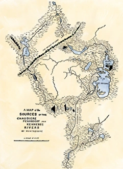
Maine map used in Arnolds invasion of Quebec, 1775Montresors map of inland Maine, used for Arnolds march to Quebec, 1775. Hand-colored woodcut of a 19th-century illustration
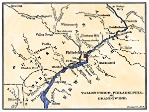
Revolutionary War sites near PhiladelphiaMap of the Philadelphia area, Valley Forge, and the Brandywine. Hand-colored woodcut of a 19th-century illustration
GPAC2A-00021Krakatoa and neighboring islets before the volcanic eruption of 1883. Hand colored woodcut of a 19th-century illustration
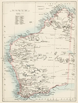
Western Australia province, 1800sMap of Western Australia, 1870s. Color lithograph reproduction of a 19th-century illustration
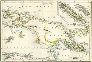
GPAC2A-00023Map of New Guinea and New Caledonia, 1870s. Printed color lithograph of a 19th-century illustration
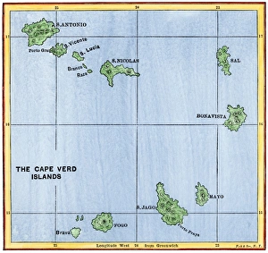
Cape Verde Islands mapMap of the Cape Verde Islands in the Atlantic. Hand-colored woodcut of a 19th-century illustration
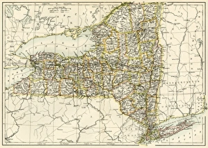
New York map, 1870sMap of New York State, 1870s. Printed color lithograph of a 19th-century illustration
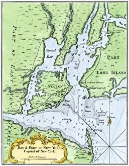
USNY2A-00037Bellins map of the New York Bay, 1764. Hand-colored woodcut reproduction of an 18th-century illustration
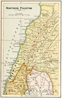
GMDE2A-00055Map of northern Palestine in ancient times. Printed color lithograph of a 19th-century illustration
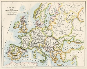
Europe at the time of the CrusadesMap of Europe during the Crusades, 1000 to 1200 AD. Printed color lithograph reproduction of a 19th-century illustration
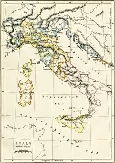
GEUR2A-00122Map of Italy showing political divisions before 1797. Color lithograph, 19th century
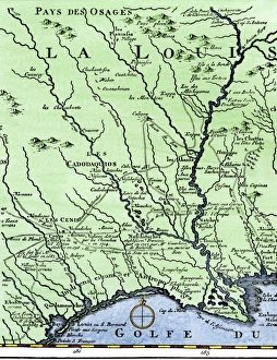
DeSotos route in LouisianaWestern part of De Sotos route, from Desisles map published in 1707. Hand-colored woodcut reproduction of an 18th-century illustration
EXPL2A-00354Dauphin Map by Pierre Desceliers made for Prince Henry (who became Henri II) by order of the French King Francis I, 1546. Printed color halftone reproduction 19th century
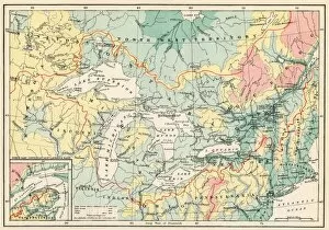
EXPL2A-00357Map of the Great Lakes and the St. Lawrence watershed. Printed color lithograph, 19th century
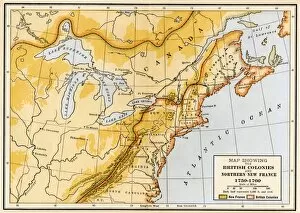
EVNT2A-00019Map showing British colonies and northern New France during the French and Indian War, 1750s. Printed color lithograph of a 19th century illustration