mail_outline sales@mediastorehouse.com
Oklahoma Territory opened to settlers, 1891Homesteaders charge at the start signal, western Oklahoma Land Rush, 1891. Hand-colored woodcut of a 19th-century illustration
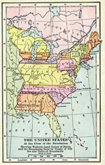
EXPL2A-00164Map of the United States at the close of the American Revolution, 1783. Printed color lithograph of a 19th-century illustration
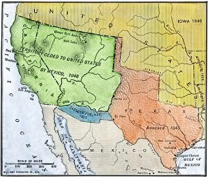
EXPL2A-00265Map of the territory ceded by Mexico to the US after the Mexican-American War, 1848-1853. Hand-colored woodcut of a 19th-century illustration
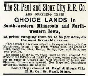
Railroad land for sale in Iowa and MinnesotaFarmland in Minnesota and Iowa for sale by the St. Paul & Sioux City Railroad Company, 1870s. Handset type advertisement with a watercolor wash
Flag of France, 1700sFrench flag marking La Verendrye expeditions claim of the northern Great Plains for France in 1743, Pierre, South Dakota. Digital photograph
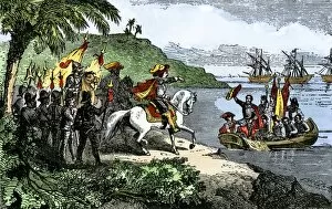
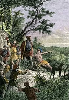
Balboa discovering the Pacific, 1513Spanish expedition under Balboa discovering the Pacific Ocean, 1513. Hand-colored woodcut of a 19th-century illustration
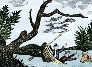
EXPL2A-00269Meriwether Lewis and William Clark expedition losing notes and specimens in a canoe accident on the upper Missouri River. Hand-colored woodcut reproduction of sketch by Patrick Goss
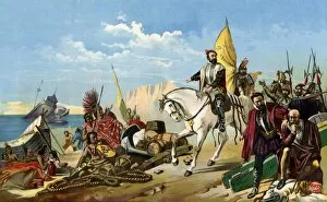
EXPL2A-00123Spanish explorer Hernando De Soto discovering the Mississippi River, 1540. Hand-colored engraving of a 19th-century illustration
Walking Purchase land claim in colonial PennsylvaniaWilliam Penns Walking Purchase agreement with Native Americans for as much land as a man could walk in 3 days. Hand-colored halftone reproduction of a 19th-century illustration
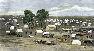
Oklahoma City settlement during the Land Rush, 1889Founding of Oklahoma City during the land rush of 1889. Hand-colored woodcut reproduction of a 19th-century photograph
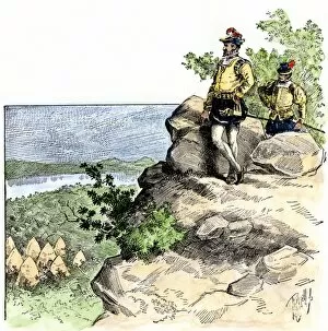
EXPL2A-00149Route of Zebulon Pike across western territory to explore Colorado region 1805 - 1806. Hand-colored woodcut of a 19th-century illustration
EXPL2A-00187Spanish explorer Hernando De Soto landing his expedition in Florida, 1539. Hand-colored woodcut of a 19th-century illustration
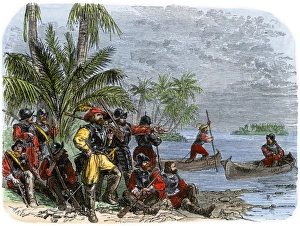
Balboa expeditions canoes on the Pacific, 1513Balboas first embarkation on the Pacific Ocean (South Sea), 1513. Hand-colored woodcut of a 19th-century illustration
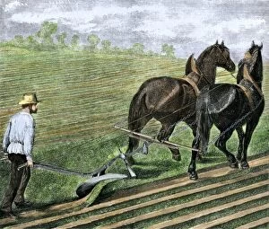
AGRI2A-00107Farmer plowing sod with a team of horses, 1800s. Hand-colored woodcut of a 19th-century illustration
EXPL2A-00066Landing of Columbus expedition on the island of Guanahane in 1492. Printed color lithograph of a 19th-century painting by Dioscoro Puebla
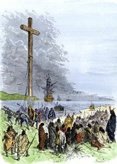
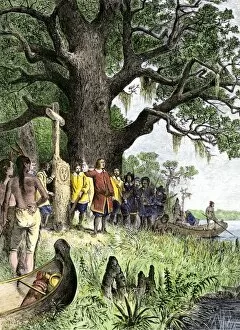
EXPL2A-00230Jacques Cartier erects a cross along the Saint Lawrence River, claiming Quebec for France, 1534. Hand-colored woodcut of a 19th-century illustration
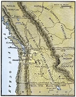
EXPL2A-00210Map of Oregon Territory showing boundary of US with English Canada under dispute until 1846. Hand-colored woodcut of a 19th-century illustration
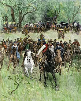
Guthrie, Oklahoma, opened to settlers, 1889Settlers claiming lots in Guthrie, Oklahoma, 20 minutes after the first train arrived, 1889. Hand-colored woodcut of a 19th-century illustration
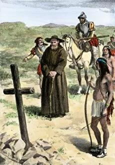
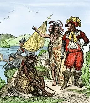
EXPL2A-00211Father Juan de Padilla finds the cross set by Coronado, 1540s. Hand-colored halftone of a 19th-century illustration
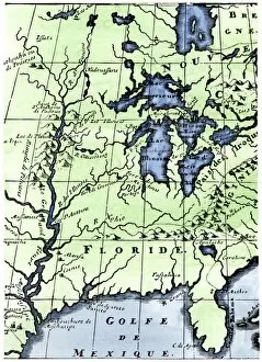
EXPL2A-00218French missionary Louis Hennepins map of the Mississippi River valley, Gulf Coast, and Great Lakes after LaSalle expeditions 1697
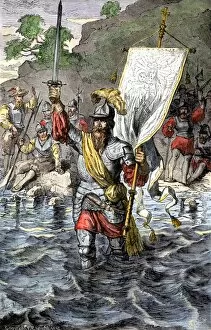
EXPL2A-00222Vasco Nunez de Balboa discovering the Pacific Ocean, 1513. Hand-colored woodcut of a 19th century illustration
EXPL2A-00235Balboa raising his sword to claim the Pacific Ocean for Spain, 1513. Hand-colored woodcut of a 19th-century illustration
EXPL2A-00260De Soto discovering the Mississippi River after an overland journey, 1540. Hand-colored woodcut of a 19th century illustration
EXPL2A-00118LaSalle at the mouth of the Mississippi River claims Louisiana for France 1682. Hand-colored woodcut of a 19th-century illustration
EXPL2A-00077Cortes scuttling his ships to cut off any chance of his mens retreat after landing in Mexico, 1518. Printed color lithograph of a 19th-century illustration
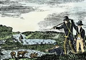
EXPL2A-00092Lewis and Clark shoot a grizzly bear, unknown to whites, during their exploration of Louisiana Territory. Hand-colored woodcut reproduction of sketch by Patrick Goss
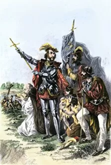
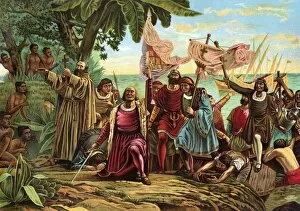
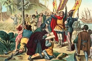
EXPL2A-00056Christopher Columbus taking possession of the New World for Spain, 1492 Printed color lithograph of a 19th-century illustration
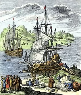
EXPL2A-00143La Salle landing in Matagorda Bay Texas to colonize Louisiana Terrritory and the Mississippi valley area, 1685. Hand-colored 19th-century woodcut reproduction of an earlier illustration
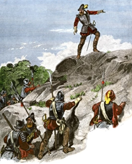
EXPL2A-00087Jacques Cartier on the summit of Mont Real, now Montreal, Canada, 1535. Hand-colored woodcut of a 19th-century illustration
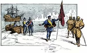
EXPL2A-00085English Explorer John Cabot landing on the shore of Canada, 1484. Hand-colored woodcut of a 19th-century illustration
Cartiers landing place on the St Lawrence, QuebecReplica cross marking Jacques Cartiers landing place on the St Lawrence River in Quebec. Digital photograph
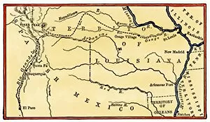
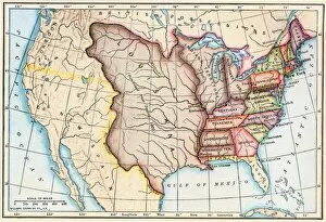
EXPL2A-00062Map of the Louisiana Purchase as understood in 1803, later modified by treaty. Printed color lithograph of a 19th-century illustration
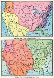
EXPL2A-00151Maps of North American colonies before and after the French and Indian War, 1700s. Printed color lithograph of a 19th century illustration