Home > Exploration
EXPL2A-00239

![]()
Wall Art and Photo Gifts from North Wind
EXPL2A-00239
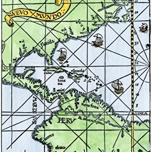
First map of the Strait of Magellan from Magellans circumnavigation of the earth in 1519 showing north at the bottom.
Hand-colored 19th-century woodcut reproduction of Pigafettas 16th century map
Media ID 5880886
© North Wind Picture Archives
1500s 1519 16th Century Atlantic Cape Horn Cartography Circumnavigation Discover Expedition Exploration Explore Ferdinand Magellan Journey Magellan Navigate Navigation New World Ocean Pacific Patagonia Portuguese South America Southern Strait Strait Of Magellan Tierra Del Fuego Travel Voyage
FEATURES IN THESE COLLECTIONS
> Maps
MADE IN THE UK
Safe Shipping with 30 Day Money Back Guarantee
FREE PERSONALISATION*
We are proud to offer a range of customisation features including Personalised Captions, Color Filters and Picture Zoom Tools
SECURE PAYMENTS
We happily accept a wide range of payment options so you can pay for the things you need in the way that is most convenient for you
* Options may vary by product and licensing agreement. Zoomed Pictures can be adjusted in the Basket.