Home > Exploration
EXPL2A-00220

![]()
Wall Art and Photo Gifts from North Wind
EXPL2A-00220
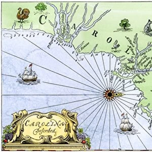
John Whites map of the Virginia and Carolina coast where Roanoke Colony was located, 1500s.
Hand-colored 19th-century reproduction engraving
Media ID 5880916
© North Wind Picture Archives
1500s 16th Century Atlantic Carolina Cartography Chart Coast Colonial Colony Compass English Island James River John White New World North Carolina Ocean Outer Banks Roanoke Colony Settlement Ship Virginia
FEATURES IN THESE COLLECTIONS
> Maps
MADE IN THE UK
Safe Shipping with 30 Day Money Back Guarantee
FREE PERSONALISATION*
We are proud to offer a range of customisation features including Personalised Captions, Color Filters and Picture Zoom Tools
SECURE PAYMENTS
We happily accept a wide range of payment options so you can pay for the things you need in the way that is most convenient for you
* Options may vary by product and licensing agreement. Zoomed Pictures can be adjusted in the Basket.