Home > American history
EXPL2A-00210

![]()
Wall Art and Photo Gifts from North Wind
EXPL2A-00210
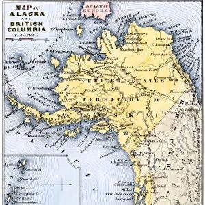
Map of Oregon Territory showing boundary of US with English Canada under dispute until 1846.
Hand-colored woodcut of a 19th-century illustration
Media ID 5877394
© North Wind Picture Archives
Border Boundary British British Columbia Canada Canadian Claim Colony English Land Land Claim North West Oregon Oregon Territory Pacific Pacific Northwest Russian Territory Washington Washington State
FEATURES IN THESE COLLECTIONS
> Maps
MADE IN THE UK
Safe Shipping with 30 Day Money Back Guarantee
FREE PERSONALISATION*
We are proud to offer a range of customisation features including Personalised Captions, Color Filters and Picture Zoom Tools
SECURE PAYMENTS
We happily accept a wide range of payment options so you can pay for the things you need in the way that is most convenient for you
* Options may vary by product and licensing agreement. Zoomed Pictures can be adjusted in the Basket.