mail_outline sales@mediastorehouse.com
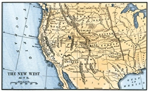
Western frontier in the 1880sMap of the American West in the 1880s. Hand-colored woodcut of a 19th century illustration
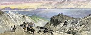
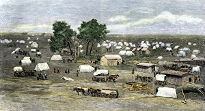
Pioneers approaching the Great Salt Lake, UtahMormon Trail settlers approaching the Great Salt Lake, Utah, 1800s. Hand-colored woodcut of a 19th-century illustration
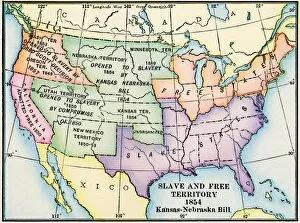
EXPL2A-00312Map of slave and free areas of the United States in 1854, at the time of the Kansas-Nebraska Bill. Printed color lithograph 19th century
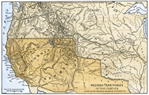
Western boundary with Mexico, 1840sMexican possessions and western US territories in the 1840s. Hand-colored woodcut of a 19th-century illustration
North American colonies in 1733European claims in North America in 1733, when the last English colony, Georgia, was founded. Color lithograph
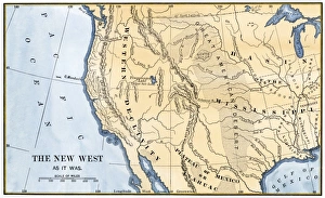
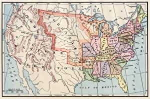
Western US frontier, early 1800sMap of the western frontier in the United States, 1800s. Hand-colored woodcut of a 19th-century illustration
Oklahoma City settlement during the Land Rush, 1889Founding of Oklahoma City during the land rush of 1889. Hand-colored woodcut reproduction of a 19th-century photograph
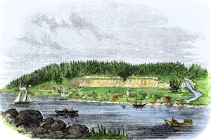
Oregon City, terminus of the Oregon Trail, 1850sOregon City on the Willamette River, first capital of Oregon Territory, 1850s. Hand-colored woodcut of a 19th-century illustration
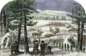
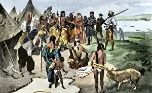
Native Americans herding reindeer in AlaksaReindeer chased into a corral by Native Americans in Alaska, 1800s. Hand-colored woodcut of a 19th-century illustration
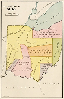
Ohios early land divisionsLand division and early settlements in Ohio Territory. Printed color lithograph of a 19th-century illustration
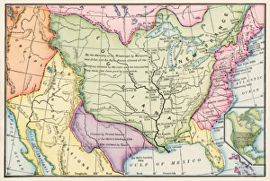
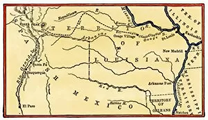
EXPL2A-00149Route of Zebulon Pike across western territory to explore Colorado region 1805 - 1806. Hand-colored woodcut of a 19th-century illustration
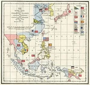
EVNT2A-00313Map of the China Seas, Philippines, and European colonies in the region, 1898. Printed color lithograph 19th century
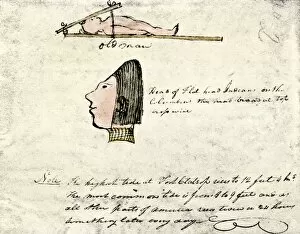
EXPL2A-00167William Clarks sketch of Flathead Indians in his diary of the Lewis and Clark expedition, 1804-1806 Hand-colored halftone reproduction of a 19th-century photograph of Clarks handwritten page
EXPL2A-00170La Salle and his companions exploring the lower Mississippi River for France, 1682. Hand-colored woodcut of a 19th-century illustration
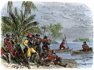
Balboa expeditions canoes on the Pacific, 1513Balboas first embarkation on the Pacific Ocean (South Sea), 1513. Hand-colored woodcut of a 19th-century illustration
North American territories in 1783North America at the close of the Revolution - Treaty of Paris, 1783. Printed color lithograph
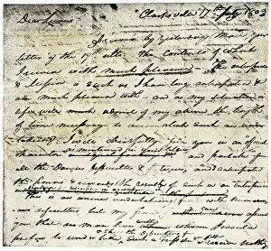
EXPL2A-00339William Clarks letter accepting Lewiss invitation to join the Corps of Discovery expedition, dated Clarksville 1803. Printed halftone reproduction with a watercolor wash
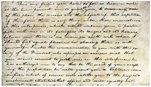
William Clarks invitation from Meriwether Lewis, 1804Meriwether Lewiss letter inviting William Clark to join the expedition to explore the Louisiana Territory. Printed halftone reproduction with a watercolor wash
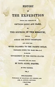
EXPL2A-00351Title page of the first publication of Lewis and Clarks journal and notes, 1814. Woodcut with a watercolor wash
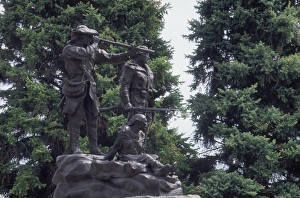
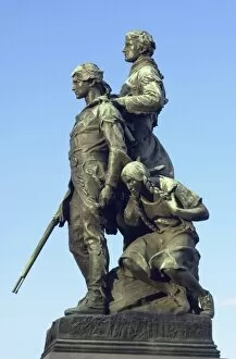
Lewis and Clark monument at Fort Benton, MontanaStatue of Sacagawea guiding Lewis and Clark at Fort Benton, Montana. Photograph
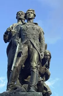
PEXP2D-00014Explorers Meriwether Lewis and William Clark with their Native American guide Sacagawea. Digital photograph of a bronze statue in Charlottesville Virginia
PEXP2D-00011Explorers Meriwether Lewis and William Clark with their Native American guide Sacagawea. Digital photograph of a bronze statue in Charlottesville, Virginia
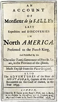
PEXP2A-00051Title page of Henri de Tontis account of the La Salle expedition. Woodcut with a watercolor wash of the English edition, printed in London 1698
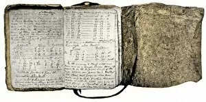
EXPL2A-00116Diary kept by William Clark of the Lewis and Clark expedition 1804 - 1806. Hand-colored halftone of a 19th-century reproduction of the diary
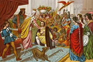
EXPL2A-00057Columbus bringing gifts from the New World to Queen Isabella of Spain 1492. Printed color lithograph of a 19th-century illustration
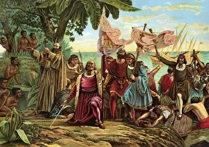
EXPL2A-00066Landing of Columbus expedition on the island of Guanahane in 1492. Printed color lithograph of a 19th-century painting by Dioscoro Puebla
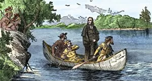
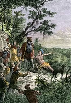
EXPL2A-00133Lewis and Clark expedition trying to make friends with Native Americans during their exploration of Louisiana Territory. Hand-colored halftone of a 19th-century illustration
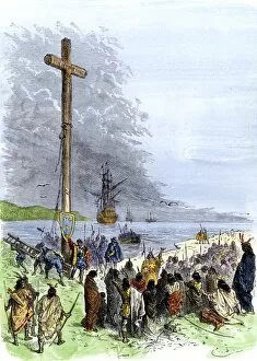
EXPL2A-00230Jacques Cartier erects a cross along the Saint Lawrence River, claiming Quebec for France, 1534. Hand-colored woodcut of a 19th-century illustration
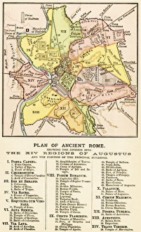
Ancient Romes 14 regionsMap of ancient Rome showing the fourteen regions under Caesar Augustus, circa 1 AD. Printed color lithograph reproduction of a 19th-century illustration
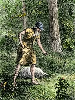
PEXP2A-00056Johnny Appleseed planting apple trees in the Ohio wilderness. Hand-colored woodcut of a 19th-century illustration
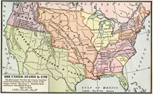
EXPL2A-00039Map of the US in 1792, showing colonial claims on Oregon Territory. Printed color halftone of a 19th century illustration
EXPL2A-00038Map of the U.S. boundary disputes with Spain and Great Britain, 1810-1812. Printed color lithograph of a 19th-century illustration
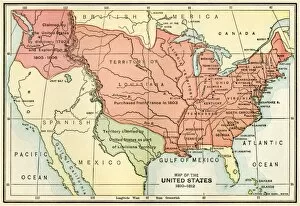
United States territory in 1830Map of the United States in 1830. Printed color lithograph
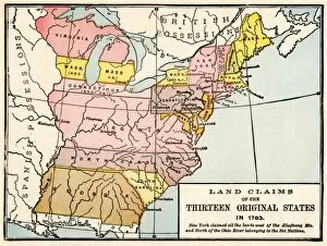
EXPL2A-00191Map showing land claims of the 13 original states in 1783. Printed color lithograph of a 19th-century illustration
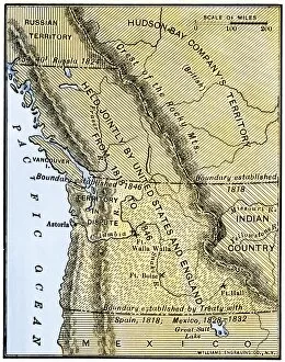
EXPL2A-00210Map of Oregon Territory showing boundary of US with English Canada under dispute until 1846. Hand-colored woodcut of a 19th-century illustration
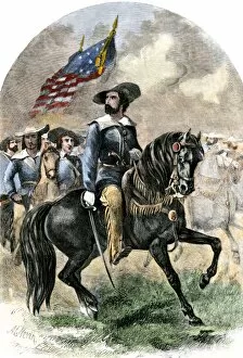
PEXP2A-00043General John C. Fremont in his prairie uniform leading an expedition into western territory. Hand-colored woodcut of a 19th-century illustration
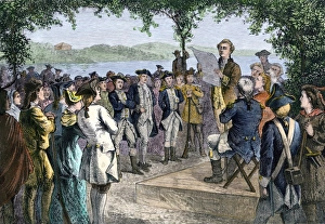
Ohio Territory government established at Marietta, 1788Ohio pioneers installing territorial government at Marietta, late 1700s. Hand-colored woodcut of a 19th-century illustration
Guthrie, Oklahoma, opened to settlers, 1889Settlers claiming lots in Guthrie, Oklahoma, 20 minutes after the first train arrived, 1889. Hand-colored woodcut of a 19th-century illustration
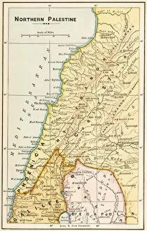
GMDE2A-00055Map of northern Palestine in ancient times. Printed color lithograph of a 19th-century illustration
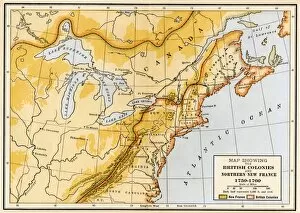
EVNT2A-00019Map showing British colonies and northern New France during the French and Indian War, 1750s. Printed color lithograph of a 19th century illustration
Site of Henri de Tontis French settlement, 1686Replica of cross marking Henri de Tontis 1686 French trading settlement, Arkansas Post National Memorial, Arkansas. Digital photograph
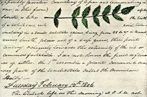
EXPL2A-00168William Clarks sketch of an evergreen shrub leaf in the Lewis and Clark expedition diary, 1806. Hand-colored halftone reproduction of a 19th-century photograph of Clarks handwritten page
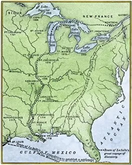
EXPL2A-00171Map showing the route of La Salles explorations in North America, late 1600s. Hand-colored woodcut of a 19th-century illustration
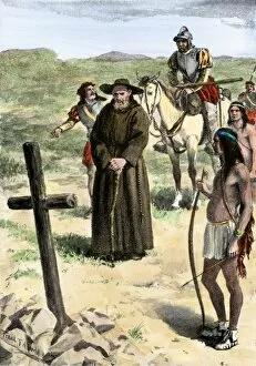
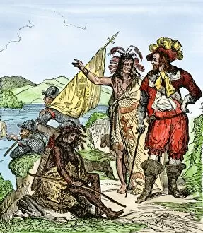
EXPL2A-00211Father Juan de Padilla finds the cross set by Coronado, 1540s. Hand-colored halftone of a 19th-century illustration
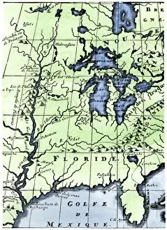
EXPL2A-00218French missionary Louis Hennepins map of the Mississippi River valley, Gulf Coast, and Great Lakes after LaSalle expeditions 1697
EXPL2A-00222Vasco Nunez de Balboa discovering the Pacific Ocean, 1513. Hand-colored woodcut of a 19th century illustration
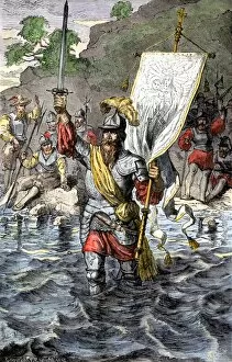
EXPL2A-00235Balboa raising his sword to claim the Pacific Ocean for Spain, 1513. Hand-colored woodcut of a 19th-century illustration
EXPL2A-00260De Soto discovering the Mississippi River after an overland journey, 1540. Hand-colored woodcut of a 19th century illustration