mail_outline sales@mediastorehouse.com
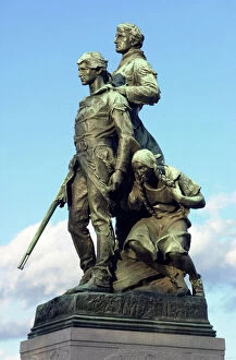
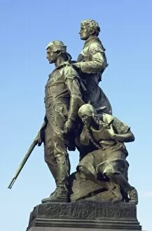
PEXP2D-00013Explorers Meriwether Lewis and William Clark with their Native American guide Sacagawea. Digital photograph of a bronze statue in Charlottesville Virginia
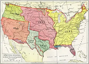
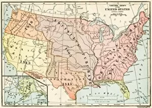
Growth of the United States to 1853U.S. map, showing territorial growth to 1853. Printed color lithograph of a 19th-century illustration
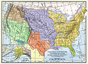
US territorial acquisition during the 1800sMap showiing the territorial growth of the continental US 1776 to 1899. Hand-colored woodcut of a 19th-century illustration
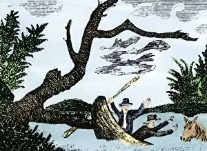
EXPL2A-00269Meriwether Lewis and William Clark expedition losing notes and specimens in a canoe accident on the upper Missouri River. Hand-colored woodcut reproduction of sketch by Patrick Goss
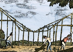
Fort Mandan constructed by Lewis and Clark, 1803Lewis and Clark expedition overwintering along the Missouri River near a Mandan village, 1803-1804. Hand-colored woodcut of a Patrick Goss drawing, a member of the expedition
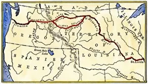
EXPL2A-00035Map of the Lewis and Clark route across Louisiana Territory, 1804-1806. Hand-colored woodcut of a 19th-century illustration
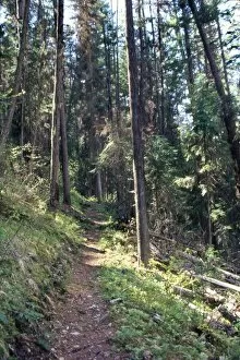
Lolo Creek in the Bitterroot Range, MontanaLolo Creek on Lewis and Clarks trail over the Bitterroot Mountains in Montana. Photograph
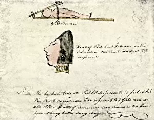
EXPL2A-00167William Clarks sketch of Flathead Indians in his diary of the Lewis and Clark expedition, 1804-1806 Hand-colored halftone reproduction of a 19th-century photograph of Clarks handwritten page
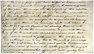
EXPL2A-00339William Clarks letter accepting Lewiss invitation to join the Corps of Discovery expedition, dated Clarksville 1803. Printed halftone reproduction with a watercolor wash
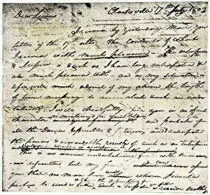
William Clarks invitation from Meriwether Lewis, 1804Meriwether Lewiss letter inviting William Clark to join the expedition to explore the Louisiana Territory. Printed halftone reproduction with a watercolor wash
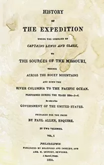
EXPL2A-00351Title page of the first publication of Lewis and Clarks journal and notes, 1814. Woodcut with a watercolor wash
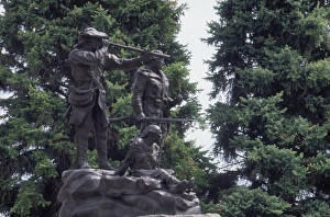
Lewis and Clark monument at Fort Benton, MontanaStatue of Sacagawea guiding Lewis and Clark at Fort Benton, Montana. Photograph
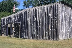
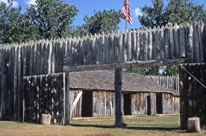
EXPL2P-00031Fort Mandan, a reconstructed Lewis and Clark campsite on the Missouri River, North Dakota. Photograph
PEXP2D-00014Explorers Meriwether Lewis and William Clark with their Native American guide Sacagawea. Digital photograph of a bronze statue in Charlottesville Virginia
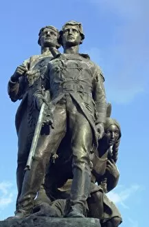
PEXP2D-00011Explorers Meriwether Lewis and William Clark with their Native American guide Sacagawea. Digital photograph of a bronze statue in Charlottesville, Virginia
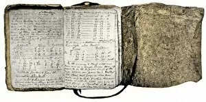
EXPL2A-00116Diary kept by William Clark of the Lewis and Clark expedition 1804 - 1806. Hand-colored halftone of a 19th-century reproduction of the diary
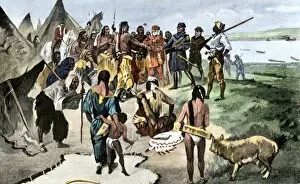
EXPL2A-00133Lewis and Clark expedition trying to make friends with Native Americans during their exploration of Louisiana Territory. Hand-colored halftone of a 19th-century illustration
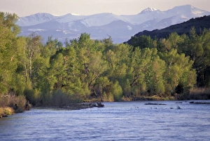
Tobacco Root Mountains and the Jefferson River, MontanaJefferson River, named for Thomas Jefferson by Lewis and Clark. Photograph
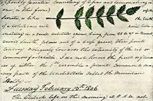
EXPL2A-00168William Clarks sketch of an evergreen shrub leaf in the Lewis and Clark expedition diary, 1806. Hand-colored halftone reproduction of a 19th-century photograph of Clarks handwritten page
EXPL2P-00037Fort Mandan, reconstructed Lewis and Clark campsite on Missouri River, North Dakota. Photograph
EXPL2P-00061Lewis and Clark trail over Lolo Pass, Bitterroot Mountains, Montana. Photograph
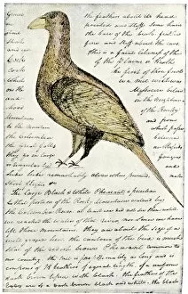
EXPL2A-00117Sketch by William Clark of Cock of the Plains in the Lewis and Clark expedition diary. Hand-colored halftone of a 19th-century reproduction of the diary
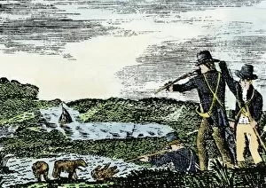
EXPL2A-00092Lewis and Clark shoot a grizzly bear, unknown to whites, during their exploration of Louisiana Territory. Hand-colored woodcut reproduction of sketch by Patrick Goss
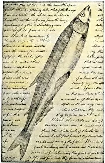
EXPL2A-00166William Clarks sketch of a trout in the Lewis and Clark expedition diary. Hand-colored halftone reproduction of a 19th-century photograph of Clarks handwritten page
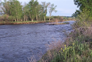
Clark Fork, MontanaClark Fork River, named for William Clark, named by Lewis and Clark expedition in Montana. Photograph
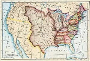
EXPL2A-00041Map of territorial growth of the United States from 1783-1867. Printed color lithograph of a 19th-century illustration
EXPL2A-00062Map of the Louisiana Purchase as understood in 1803, later modified by treaty. Printed color lithograph of a 19th-century illustration