mail_outline sales@mediastorehouse.com
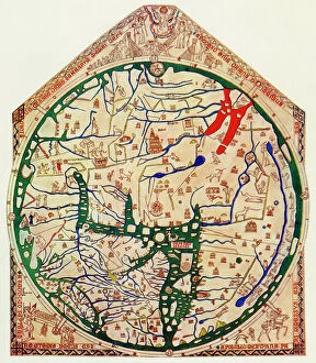
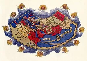
EXPL2A-00352The Hereford Mappa Mundi of 1280 - Jerusalem is at the center, Europe lower left, Africa lower right. Printed color halftone reproduction 19th century
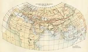
EXPL2A-00014Ptolemys map of the world, illustrating a concept of the flat earth. Hand-colored 19th-century woodcut reproduction
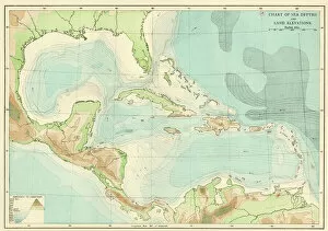
EXPL2A-00377Chart of the West Indies sea depths and land elevations. Printed color lithograph of a 19th-century illustration
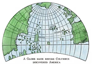
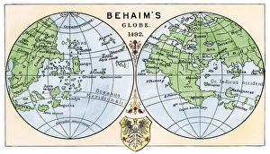
Globe of 1492, lacking the New WorldDiagram of Martin Behaims globe, made just before Columbus discovered America. Hand-colored woodcut of a 19th-century illustration
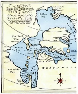
EXPL2A-00284Early map of Hudsons Strait and Hudsons Bay, 1662, in Arctic Canada. Hand-colored 19th-century woodcut reproduction
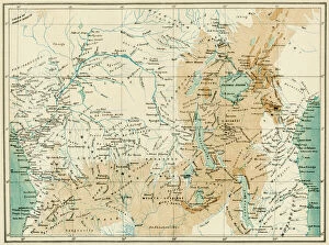
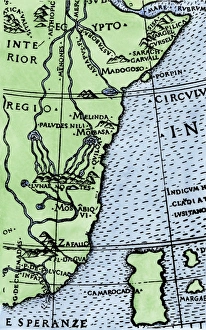
EXPL2A-00366Map of equatorial Africa as known in the 1870s. Printed color lithograph, 19th century
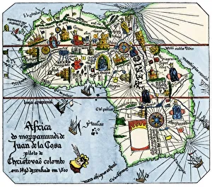
Vasco da Gamas route around Africa, 1400sAfrica as known after Vasco da Gamas discoveries, from map of Juan de la Cosa, 1500. Hand-colored woodcut reproduction
EXPL2A-00184Part of the 1613 Samuel de Champlain map of New France. Hand-colored woodcut of a 19th-century reproduction of the original ma
Behaims 1492 globe showing a round Earth but no New WorldDiagram of globe by Martin Behaim, without the New World, created in 1492. Hand-colored woodcut of a 19th-century illustration
EXPL2A-00065World map of the flat earth printed by Beatus Rhenanus Bildaus Rheinau early 1500s - North is left, Mediterranean Sea middle Printed color lithograph reproduction 19th century
EXPL2A-00353Ptolemys map of the world shown in red, true locations in black. Printed color lithograph 19th century
EXPL2A-00220John Whites map of the Virginia and Carolina coast where Roanoke Colony was located, 1500s. Hand-colored 19th-century reproduction engraving
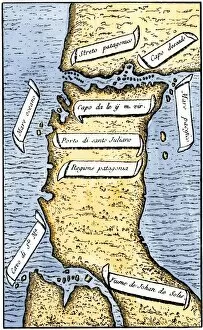
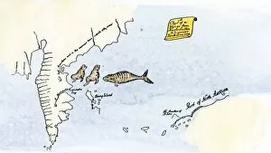
EXPL2A-00239First map of the Strait of Magellan from Magellans circumnavigation of the earth in 1519 showing north at the bottom. Hand-colored 19th-century woodcut reproduction of Pigafettas 16th century map
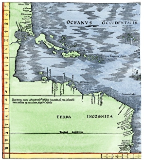
Early map of the New World, 1513Tabula Terre Nove 1513: the Admirals Map of the Caribbean and Terra Incognita (unknown lands). Hand-colored woodcut reproduction
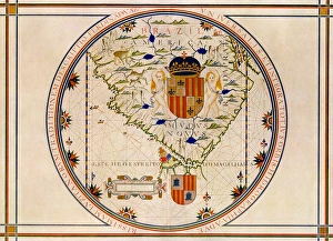
Portuguese map of the tip of South America, 1571Map of South America printed in Lisbon, 1571. Printed color halftone reproduction
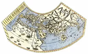
EXPL2A-00061Ptolemys world map, circa 150 AD, from the edition of 1472. Color halftone reproduction of the first printed edition of 1472
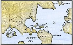
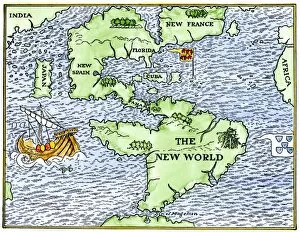
EXPL2A-00147World map after the disoveries of Columbus and Balboa, showing the prevalent idea that South America was attached to Asia. Hand-colored woodcut of a 19th-century illustration
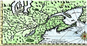
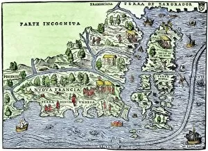
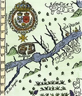
EXPL2A-00126Map of New France, 1550, showing the coast of Canada and the Gulf of Saint Lawrence Hand-colored woodcut
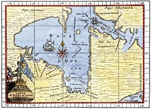
EXPL2A-00190Map of Hudsons Bay, Canada, showing Hudsons Strait, 1722. Hand-colored 19th-century woodcut reproduction of an 18th-century map
EXPL2A-00058Samuel de Champlains map of the Gaspee and Gulf of the Saint Lawrence River, 1632. Hand-colored woodcut reproduction of the original map
EXPL2A-00297Champlains 1613 map of his settlement at Port Royal, now Annapolis Royal, Nova Scotia, Canada. Hand-colored 19th-century woodcut reproduction of Champlains drawing
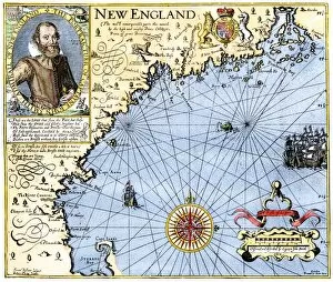
EXPL2A-00291John Smiths map of New England, with inset portrait, circa 1620. Hand-colored 19th-century woodcut reproduction of the original
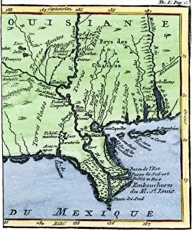
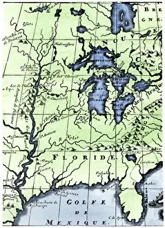
EXPL2A-00302Map of Louisiana, 1744, showing the mouths of the Mississippi River while part of New France. Hand-colored woodcut reproduction of the map
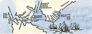
Cape of Good Hope mapped at its correct latitude, 1508First map showing Africas southern point at the correct latitude, from Ruysch 1508. Hand-colored woodcut reproduction of a 16th-century illustration
EXPL2A-00354Dauphin Map by Pierre Desceliers made for Prince Henry (who became Henri II) by order of the French King Francis I, 1546. Printed color halftone reproduction 19th century
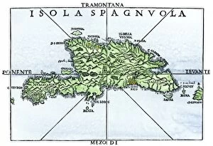
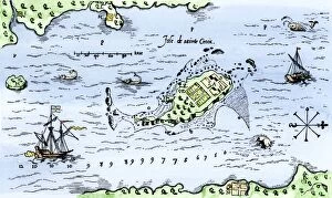
EXPL2A-00227Map of Hispaniola in 1534, from cartography of Peter Martyr and Oviedo. Hand-colored 19th-century woodcut reproduction of a 16th-century map
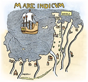
India coast, 1459The Malabar coast of India, from Fra Mauros map, 1459 (south is at the top). Digitally colored woodcut reproduction
EXPL2A-00197Hudsons map of his voyages in the Arctic, published in 1612. Hand-colored 19th-century reproduction of a woodcut from Hudsons " Voyages" published in 1612
EXPL2A-00218French missionary Louis Hennepins map of the Mississippi River valley, Gulf Coast, and Great Lakes after LaSalle expeditions 1697
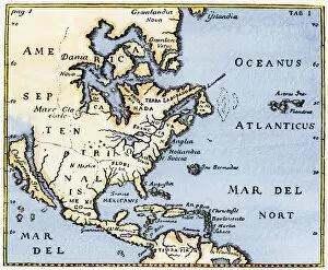
EXPL2A-00375Map of North America as known in the mid-1600s. Hand-colored woodcut reproduction of an illustration in Campanius, 1702
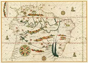
EXPL2A-00021Map of South America from the Spanish atlas executed at Messina in 1582 by Joan Martines. Printed color lithograph reproduction 19th century
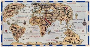
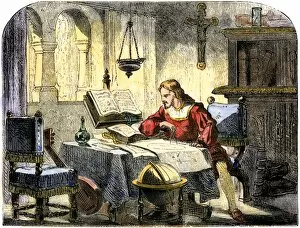
EXPL2A-00032Christopher Columbus studying a map in his studio in Spain 1400s. Hand-colored woodcut of a 19th-century illustration
Isthmus of Panama, 1744Map from Oexmelins Histoire of the Isthmus of Panama, 1744. Hand-colored woodcut
EXPL2A-00148New World geography according to a mapmaker of 1540. Hand-colored woodcut of a 19th-century illustration
EXPL2A-00150Chart of Vitus Berings voyage from Kamchatka, Russia, to North America, 1700s. Hand-colored 19th-century woodcut reproduction
EXPL2A-00246Hochelaga, site of Montreal, shown as a Native American village in Lescarbots map, 1609. Hand-colored 19th-century woodcut reproduction of a 17th-century document
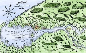
EXPL2A-00296Map of Champlains settlement on the Isle de Sainte Croix, Canada, 1613. Hand-colored 19th-century woodcut reproduction of the original map